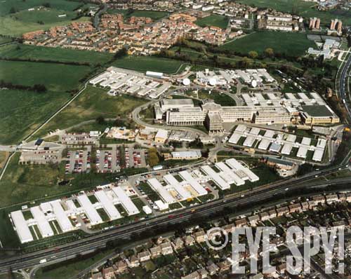
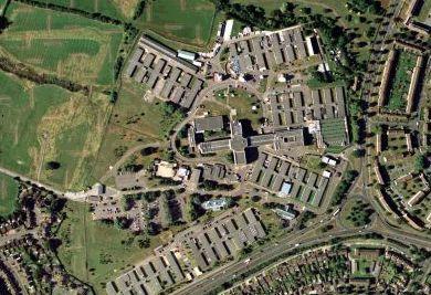
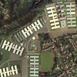
The existing GCHQ buildings at Benhall, Cheltenham
Photo courtesy of www.eyespymag.com
24 June2004: The operator of this UK-based site has removed it today due to public and press furor. The operator asked Cryptome to remove the link to the site from this file and another long-standing link to it from Cryptome's Eyeball series index.
The site operator was told several times in recent days by the UK D-Notice Committee that nothing on the site was illegal but today the Committee agreed that it was best to close the site. To assure continuing access to the withdrawn information Cryptome has mirrored the site without approval of the site originator.
See related: http://cryptome.org/terror-click.htm
Alan
Turnbull’s
"Secret Base" Page
http://homepage.ntlworld.com/alan-turnbull/secret.htm
Website created: August 2003
Page last updated: 21st June 2004
| COPYRIGHT
© 2003-2004, Alan Turnbull A Pagliacci Production |
Introduction
What makes a "Secret Base" secret? By "base", I mean those Government
installations or military sites you've seen surrounded by razor wire fences
and guarded by Ministry of Defence (MoD) police. How on earth can these sites
be secret? The UK Government hasn't (yet) developed stealth technology in
the visible range of the electromagnetic spectrum. So they can't very well
make, say,
Faslane
nuclear submarine base suddenly disappear as you come around the
corner!
No, it's actually much simpler than that. A Government laboratory or military
base can be made to "disappear" by just deleting it from Ordnance Survey
(OS) maps! But how? Well, you need to appreciate that OS is essentially a
Government agency within the MoD. Just look-up the derivation of the word
"ordnance" and all will become clear.
All inclusions on OS maps were once vetted by the UK Government's
D-notice
committee. You may have heard of this before. When the Government
wanted to "gag" newspaper editors to stop them revealing embarrassing details
about MoD-related stories, it was called "slapping a D-notice" on them. Any
sensitive sites were mysteriously removed from maps by men in cigar smoke
filled rooms in Whitehall and just ended up appearing as farmers' fields!
In February 2004, the Secretary of the D-notice committee, Rear Admiral Nick
Wilkinson, contacted me to assure me that things have changed for the better
and that the system has been overhauled in recent years. With the introduction
of Internet-based mapping and aerial photography data, he insists that the
Committee is now an independent and purely advisory body.
Alerted to the issues highlighted in this web page, Mr. Wilkinson told me
that Ordnance Survey's removal of MoD-related sites from their maps is no
longer appropriate in today's Internet climate. He assures me that the fact
that they still show sensitive sites as empty fields is because of their
own organisation's inertia, rather than any sinister Government
involvement.
Indeed, the high resolution aerial photography of the UK's "Secret Bases",
offered for sale on the Internet by Getmapping plc, was cleared by Mr. Wilkinson.
Even so, various defence analysts raised concerns, as detailed in a
BBC
News article. Getmapping's co-founder and MD, Tristram Cary, is a
former Royal Navy officer and software project director in the defence
industry.
In this web page I revisit themes explored on my
Emmerdale
Page and make further use of the Internet research tools outlined
there -
Getmapping,
Multimap,
Streetmap,
Old
Maps and Ordnance Survey's own
Get-a-map.
Follow my links by clicking on the bold references in
blue like the ones above. First, though,
please refer to my
IMPORTANT
notes further below!
As you hover over each link, it will be
highlighted
(assuming that your browser supports "Style Sheets"). When you click on a
link, a new window will open. You may have to maximise the size of this window
by dragging its edges so that it fills the screen. When you've finished browsing
the links, close the newly-opened window to return to this page. If you've
done your own further exploration within each link, you may need to do this
several times. You may also need to close some pop-up advertisement windows
when exploring these links.
If you discover any broken links, please report these to me using the email
button at the bottom of this page. However, please bear in mind that if you
find any links behaving in an unexpected manner, the particular website's
server may be experiencing temporary problems.
Perhaps you would also like to try my other web pages by visiting my home
page at:-
www.alan-turnbull.co.uk
Internet research tools and
notes
To read my important notes and learn all about the research tools I used
for my "Secret Base" Page, just click on the button below.
Map link source:
Further map link options (for
Multimap / Streetmap only)
Map size: Printer friendly: Map type:
"Secret
base" locations revealed!
There are some classic signs to look for on OS maps, when trying to find MoD related sites. You might see buildings which are geometrically shaped, like the MoD Procurement Executive and Warship Support Agency at
Abbey Wood in Bristol. Some are made easy
by actually labelling them "Government Offices" like the Defence Logistics
Organisation (DLO) near Bath, on the site of an old country estate at
Ensleigh. The DLO's other site in Bath can
be spotted at
Fox Hill.
The two GCHQ spy centre sites in Cheltenham at
Benhall and
Oakley don't at first stick out when viewed
at 1:50000 scale. But go to the Get-a-map site and view
GCHQ Benhall and
GCHQ Oakley at 1:25000. They suddenly emerge
as geometrically shaped buildings and get labelled "Government Offices".
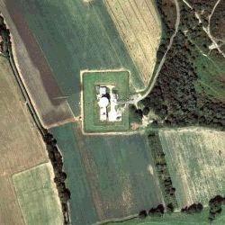
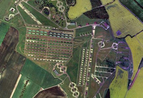
Furthermore, view Multimap's aerial photograph of
GCHQ
Benhall (below) and notice the field just to the west of the main
buildings. This is where the brand new GCHQ Doughnut complex (further below)
has been built.
The existing GCHQ buildings at Benhall,
Cheltenham
Photo courtesy
of www.eyespymag.com
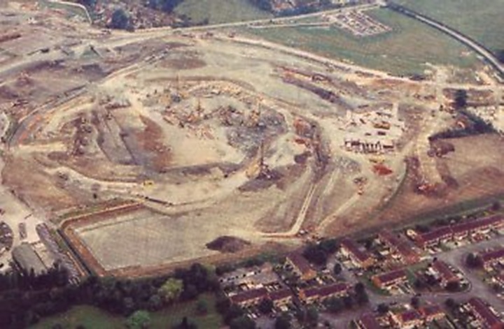
The GCHQ Doughnut building site at Benhall,
Cheltenham
Photo courtesy
of www.globalsecurity.org
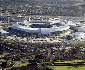
The new GCHQ Doughnut building at Benhall,
Cheltenham
Photo courtesy
of http://news.bbc.co.uk
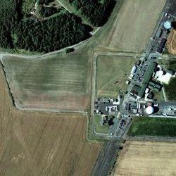
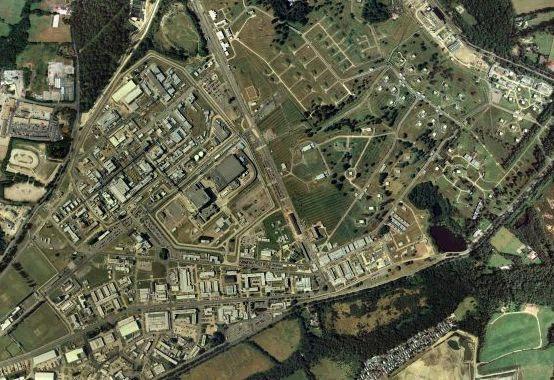
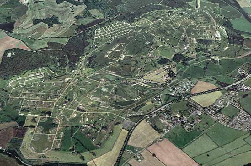
Getmapping, the company providing the aerial photography for many
Internet mapping web sites, has announced improved resolution data - the
flights for which were performed in 2002. This new data is currently only
available for a few selected towns and cities. As luck would have it, Cheltenham
is one of those places!
Compare the latest image (below left, taken in 2002) with the old image (below
right, taken in 1999). Note the clear difference in image quality and how
some of the old GCHQ Benhall buildings were demolished to make way for the
Doughnut.
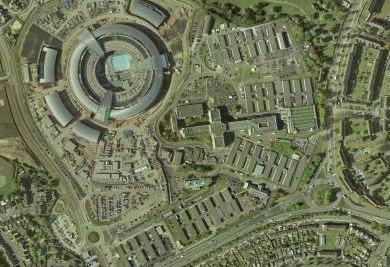 |
 |
The 2002 and 1999 versions
of Getmapping's image of GCHQ Benhall
Aerial photo data courtesy
of www.getmapping.com
COPYRIGHT © Getmapping plc
Sometimes you can stumble upon interesting sites by accident. Hanslope
Park in Buckinghamshire looks like one of those stately homes you would
pass on a Sunday drive out with the kids. It is designated "The Foreign and
Commonwealth Office". However, a further look using the Get-a-map
site reveals rather more than your usual country pile.
Hanslope Park was originally acquired by the Foreign Office at a time when
the Secret Service was in its infancy and GCHQ-type work was done at nearby
Bletchley Park, in the days of Alan Turing. Hanslope has been massively
expanded in more recent decades. It now houses annexes full of the latest
supercomputers and communications equipment - and we're not talking "Intel
Pentium 5"! The Hanslope Park estate (below) is home to MI6 operatives who
process and analyse data sent from GCHQ in Cheltenham and Menwith Hill in
North Yorkshire.
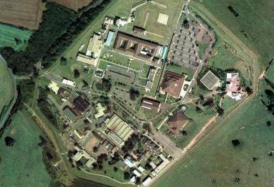
Aerial
view of MI6's computer annexes at Hanslope Park
Aerial
photo data courtesy of www.getmapping.com
COPYRIGHT © Getmapping plc
Another classic sign to look for is the label "Works" or "Depot".
This is usually an indication that a site has Government and/or military
activities. Take a look at this one at
West Moors near Wimborne, Dorset. It is actually a fuel storage
and distribution centre for the Army and is designated the Defence Petroleum
Centre.
Any site which has many buildings and roads laid out in a regular pattern
can usually indicate a storage depot of some kind. For instance,
DSDA Longtown near Carlisle is a massive munitions and equipment
store for the Army. DSDA is the Government's Defence Storage and Distribution
Agency. On the Streetmap and Multimap sites, their old OS data apparently
shows nothing to get excited about. However, go to the Get-a-map site and
try again.
DSDA Longtown suddenly comes to life! Note the system of
rail lines serving the site, too.
When considering DSDA, take a look also at the Army Base Repair Organisation
(ABRO) whose HQ is at
Andover in Hampshire. Consider too, the Defence Aviation
Repair Agency (DARA) whose HQ can be found at
St. Athan, near Barry in South Wales. ABRO and DARA provide
engineering maintenance expertise to the Army and RAF, respectively.
DARA has key sites dotted around the UK at
Fleetlands in Gosport, Hampshire, at
Sealand in Deeside, Flintshire and at
Almondbank near Perth in Scotland. However, DARA Almondbank's
other depot is hidden a little further north, on the banks
of the River Almond, as the name suggests. DARA Fleetlands is right next
door to the Royal Naval Armaments Depots -
RNAD Gosport and
RNAD Frater.
Both RNAD Gosport and RNAD Frater are mysteriously absent from the older
Multimap and Streetmap 1:50000 scale maps, but hop over to Ordnance Survey's
own Get-a-map service and their newer
1:50000 and
1:25000 maps of the whole area tell the true story!
Another RNAD site can be spotted just north of the Tamar Bridge at
Ernesettle in Plymouth, Devon. Note the handy train line
going right past the depot. Now take another look, this time at the south
side of the Tamar Bridge and you'll find the Royal Navy's brand new Remote
Ammunitioning Facility - Tamar (RAFT), at
Bull Point. This base allows nuclear-powered submarines to
be loaded with their weapons in a high security and controlled environment,
but is the neighbouring RNAD Ernesettle involved?
Back to buildings in a regular pattern with a train line system: another
example can be found at
Bramley in Hampshire, near Basingstoke. This is a former
Defence Munitions (DM) storage depot and is now just used as an Army training
area - allegedly! The
aerial
photo shows the sort of fascinating detail which is not apparent
on the ground.
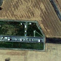
Sometimes, you can stumble upon the downright bizarre! Consider
the
Pontrilas Army Training Area (often known by its acronym
PATA), which is fairly self-explanatory. The area, north of the village of
Pontrilas in Herefordshire, close to the Welsh border, seems to be a former
munitions depot, judging by the (dismantled)
train
line system, just west of the training area's main gate, near the
village of Ewyas Harold.
The old disused munitions train line system once connected into the nearby
main line at a
branch junction in the village of Pontrilas itself, a little
further south.
But wait, hold on! What on earth is
THIS?
What is a jet aircraft doing hidden in a clearing in Gilbert's Hill Wood?
Perhaps the clue is the county location: Herefordshire. Yes, the PATA is
now used exclusively by the UK's Special Forces, the SAS. The plane (shown
in close-up further below) is rumoured to be used for counter-terrorism
training.
In the aerial photograph, note that just north of the aircraft, the SAS have
erected a barrier (indicated below) joining the two copses to the west and
east, to hide their activities from the neighbouring farm and road.
![]()
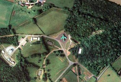
Aerial
view of the SAS counter-terrorism trainer unit at Pontrilas
Aerial
photo data courtesy of www.getmapping.com
COPYRIGHT © Getmapping plc
A site which shows a large number
of aerial symbols like this one at
Chelveston in Northamptonshire,
might mean just a group of TV and/or radio masts. But in this instance, it's
actually RAF Chelveston, former home to a USAF bomber squadron. Take another
look at the site by using Multimap's
aerial
photo with map overlay which again shows fascinating detail.
The Chelveston aerial cluster is tantalisingly close to
RAF Molesworth, which is comically
labelled as a disused airfield on OS maps! Molesworth once stored Cruise
missiles and is now one of the UK's most important and sensitive military
intelligence bases. Indeed, the former Cruise missile bunkers are marked
on the
1:25000 map and are clearly
visible on Multimap's
aerial
photo. Note that the area is ringed by triple high security
fencing.
To the east of RAF Molesworth's camp, in the
"disused airfield" area, two
main entrances to networks of underground bunkers can be spotted
here
and
here,
on Multimap's aerial photos.
Other similar military intelligence bases can be found at Chicksands (near
Shefford) and Henlow, both in Bedfordshire and at Ashby-de-la-Launde near
Digby in Lincolnshire.
DISC Chicksands is the tri-service
Defence Intelligence & Security Centre. It is the place to where, in
May 2003, journalists suggested that an alleged British Government spy within
the IRA, known as
"Stakeknife",
was to be brought for "debriefing" by MI5 and the Army.
RAF Henlow is another of those
"disused airfields". Granted, the runways are completely grassed over,
as shown on the
aerial
photo, but Henlow is home to another signals analysis centre, of
the utmost importance.
The village of Ashby-de-la-Launde in Lincolnshire sounds like the location
for one of those Sunday night Midsomer Murder dramas on TV. It is actually
the location for
RAF Digby, which on Multimap
is yet another of those "disused airfields".
A further inspection using Ordnance Survey's latest
1:50000 map from Get-a-map,
now suspiciously just shows a completely empty field. But wait, try again
with Get-a-map's
1:25000 map and that empty
field is suddenly a mass of aerial symbols!
RAF Digby is yet another very important signals analysis centre and, among
many things, is even rumoured to be involved in covert interception of mobile
telephone signals! You can just make out RAF Digby's cluster of mast assemblies
on the close-up
aerial
photo.
RAF Croughton near Brackley
in Northamptonshire is an old USAF airbase, but no runways have been apparent
for many years. On Multimap, the base appears as a significant cluster of
aerial symbols. That's because RAF Croughton is the focal point for the US
military's communications within Europe.
Curiously, the number of aerials indicated reduces noticeably when viewing
RAF Croughton on Get-a-map's latest
1:50000 map. On Get-a-map's
1:25000 map, they use that
favourite epithet, "Wireless Station".
The tiny village of Oakhanger, near
the Army camps of Bordon in Hampshire, at first sight looks like a typical
cross between rural farming landscape and wealthy stockbroker belt. However,
the village has not one but two surprises beyond its leafy hedged lanes.
Take a look at the map of the village centre and hidden among the cottages
and farms is the old
RAF Oakhanger 1001 Signals
Unit (now staffed by
Paradigm
Services, a private commercial technology company). It is now home
to military communications experts, working on the Government's new "Skynet
5" satellite project.
To the east of the village, within the Army training area known as
The Warren, is an enclosure
which on the
1:25000 OS map is suspiciously
empty.
The map data sources do not indicate any MoD activity with tell-tale aerial
symbols. It is left to Getmapping's aerial photography data (below) to finally
reveal all. It is the location for a key NATO Ground Terminal for military
communications satellites!
Note that an
additional ground terminal
(pictured further below) is set away from this main site in an annexe, just
a little further south west, but connected via a track through the
woodland!
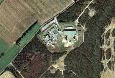
Aerial view of NATO's main Satellite Ground
Terminal at Oakhanger
Aerial
photo data courtesy of www.getmapping.com
COPYRIGHT © Getmapping plc
Aerial view of NATO's Ground Terminal annexe
at Oakhanger
Aerial
photo data courtesy of www.getmapping.com
COPYRIGHT © Getmapping plc
Another satellite ground terminal can be found at the highly sensitive military
communications base at
Defford
in Worcestershire, alongside the M5 motorway. This site provides a home to
the RAF's 1001 Signals Unit and also
QinetiQ
(pronounced "kinetic"). This organisation represents the commercial sector
wing of the Government's defence related research activities and was formed
in July 2001 out of the old Defence Evaluation and Research Agency (DERA).
At the same time, the Government's top secret laboratories, retained under
strict MoD control, were brought together to form the Defence Science and
Technology Laboratory
(DSTL)
network.
QinetiQ's Defford base features a
high
security enclave (pictured below), which is built on top of the deserted
runways, where all the really sensitive signals intelligence (SIGINT) work
is carried out.
 |
 |
Aerial view of QinetiQ Defford's
high security SIGINT enclave
Aerial photo data courtesy
of www.getmapping.com
COPYRIGHT © Getmapping plc
On the other side of the nearby town of Pershore, you'll find Throckmorton
Airfield. Yes, you guessed it, both of the Defford and Throckmorton sites
are yet more "Disused Airfields" on OS maps, which of course can only mean
they're of great MoD significance!
Throckmorton is home to the old DERA Pershore base (which itself grew out
of the Royal Radar Establishment). The site is now under the control of QinetiQ,
who have their small base hidden amongst the poultry farms and industrial
units at the northern tip of the airfield's runway.
Rather than a "Secret Base", Throckmorton's village residents are all too
familiar with the site. One end of the old airfield was used as a mass burial
ground for animal carcasses during the UK's Foot and Mouth Disease disaster.
The other end of the airfield was considered by the Government as a possible
location for a new "processing centre" for asylum seekers, until villagers
waged a very successful campaign against it.
Over on the other side of the M5 motorway, QinetiQ have significant presence
in the Worcestershire town of Great Malvern. One site at the south of the
town is at the old Royal Radar Establishment (RRE). Research work
here involves everything from stealth and radar jamming to computer hacking.
Another QinetiQ base can be found to the north of the town next to an old
DERA location, referred to by locals as MoD North Site, which is due
for redevelopment by the council.
By checking the aerial photos on Multimap or Getmapping for yourself, note
how the tell-tale geometric building layouts for both of the Malvern sites
are identical to not only the GCHQ bases in Benhall and Oakley in Cheltenham,
but also the DLO sites at Ensleigh and Fox Hill in Bath (pictured below)!
 |
 |
Aerial view of building layouts
of DLO Ensleigh and DLO Fox Hill, Bath
Aerial photo data courtesy
of www.getmapping.com
COPYRIGHT © Getmapping plc
Now, let's consider two classic examples of top secret sites which just don't
feature on maps!
The UK Government's key atomic weapons sites are located at Burghfield and
Aldermaston, both in Berkshire. But by studying the OS maps, you'd think
they might be hidden underground! The Atomic Weapons Establishment (AWE)
at Burghfield was last included on an OS map way back in 1974 and has never
been seen since. Rather comically, AWE Aldermaston (which is actually the
size of a small town) keeps appearing and disappearing, depending on which
issue of the OS map you are looking at and which scale. It reminds me of
the legend of Brigadoon!
Both the Streetmap and Multimap sites have older versions of the OS map data
which just show AWE Aldermaston (pictured below) as plain woodland
and AWE Burghfield (pictured further below) as a completely empty
field!
Ordnance Survey's Get-a-map site, which obviously has all the latest definitive
data, correctly shows the Aldermaston site (innocently labelled "Depot")
at 1:50000. But when you view the same area at 1:25000, the
site suddenly reverts to Burnham's Copse!
Even on Get-a-map, AWE Burghfield is still conspicuous by its absence at
both 1:50000 and 1:25000 scales. It is actually situated in
the blank space between Burghfield Place, Burnthouse Bridge and Grazeley
Green.
Aerial
view of AWE Aldermaston
Aerial
photo data courtesy of www.getmapping.com
COPYRIGHT © Getmapping plc
Aerial
view of AWE Burghfield
Aerial
photo data courtesy of www.getmapping.com
COPYRIGHT © Getmapping plc
Just to the north east of Burnthouse Bridge, you can make out the remains
of a
disused train branch line.
This line once connected into the nearby main line which, further south,
goes right past the former munitions depot at Bramley (see above). The maps
and photos of the Bramley munitions depot show that it, too, was once connected
into the same main line. During WWII, the AWE Burghfield site was a conventional
munitions factory.
For the residents living next to these sites, they are all too real. Especially
when they have been forced to use bottled water because of suspicions that
the local supply had been contaminated by toxic chemicals.
The AWE sites and all other sensitive UK military and Government sites, such
as Faslane nuclear submarine base, are patrolled by Ministry of Defence Police
(MDP). Their main training centre and MDP HQ is contained within a deserted
WWII USAF airbase at
RAF Wethersfield, a few miles
north west of Braintree in Essex.
Consider AWE Burghfield again but this time, view the aerial photograph on
Multimap's site and
overlay
the map. It really is a case of "now you see it - now you don't"!
Try the same with AWE Aldermaston's aerial photo and the
map
overlay.
AWE have another small site at
AWE Blacknest at Brimpton
Common, just a couple of miles to the west of AWE Aldermaston. This site,
within an old country house, contains large computer systems and is staffed
by scientists researching seismological activity, in order to verify nuclear
test bans.
Incidentally, all of the UK's non-nuclear Royal Ordnance factories were acquired
by BAe Systems (formerly British Aerospace) some time ago. One of these can
be spotted near Kidderminster in the West Midlands, at
Summerfield. This old ordnance
factory is now used by BAe Systems to research and develop motors and fuels
for rocket propulsion. The fuels are stored in huge underground silos and
the Summerfield site is patrolled by armed guards - hopefully non-smokers!
Presumably the fuels are also transported for use by the Rocket Propulsion
Establishment (RPE), again run by BAe Systems, at
Westcott in Buckinghamshire.
This site is quite close to the MoD's massive Defence Storage and Distribution
Agency (DSDA) depots at
Upper Arncott and
Ambrosden near Bicester in
Oxfordshire, both of which are served by extensive train line systems.
Once all the AWE's nuclear warheads have been developed and assembled at
Aldermaston and Burghfield, some of them are transported up to Scotland's
Royal Naval Armaments Depot (RNAD), for Faslane's Trident submarine fleet,
at
Coulport. Here, the hills
of the beautiful west coast of Scotland hide
massive bunkers in which the
nuclear weapons are kept in specially controlled conditions, ready for loading
onto Faslane's submarines at a
special jetty, just north
of the main Coulport base, which is only revealed in detail on the
1:25000 map.
A large NATO underground conventional munitions store is carved out of the
side of nearby Doune Hill at
Glen Douglas, just north of
the Faslane and Coulport depots. The massive base, which is only finally
revealed in true detail on the
OS 1:25000 scale map, extends
south east from its connection into the world famous Glasgow to Oban/Mallaig
scenic railway via Crianlarich. A little further south west on the banks
of Loch Long, you can find its associated munitions and explosives loading
jetty at
Glen Mallan (sometimes also
referred to as "Glenmallan" - all one word), which was built in 1996. Note
also, the NATO
Oil Storage Depot down the
coast, just north of Garelochhead.
A large Defence Munitions (DM) centre can be found south west of Glasgow
at
Beith in Ayrshire. This site
was originally developed in 1943 as a conventional munitions store for the
Royal Navy. Nowadays, it processes and stores Spearfish, Storm Shadow, Tomahawk
and Brimstone missiles.
On the Firth of Forth near Dunfermline, the large
RNAD Crombie can be found,
just along the coast from Her Majesty's Naval Base at
Rosyth. The Crombie base stores,
processes and maintains missiles used on Tornado and Sea Harrier jets. Crombie's
jetty, built in 1989 for both NATO and UK use, sticks out 700 metres into
the Firth.
If you travel up to the far northern highlands of Scotland, you'll stumble
across a NATO submarine base at
Loch Ewe, just south of the
tiny village of Aultbea. Loch Ewe, being a deep sea loch, enables submarines
to approach the
jetty without breaking the
water surface too soon.
The jetty at Aultbea is designated a "Z-berth" and these are dotted all around
the coast of the UK, to allow Britain's nuclear submarines to return home
temporarily for servicing. There's even a Z-berth situated in the middle
of Loch Ewe itself, marked by a
buoy but not marked on any
OS maps! Presumably, one hopes, it is marked on Royal Navy charts!
Another nuclear submarine Z-berth buoy is located off the Isle of Skye, in
the middle of
Broadford Bay, causing much
anxiety to Broadford's residents who are rightly concerned about possible
nuclear accidents.
The NATO Loch Ewe site at Aultbea and the neighbouring Naval Boom Defence
Depot at
Mellon Charles, have military
significance dating back to WWII. The location of the Boom Defence Depot
marks the start of the original protective netting which guarded the entrance
to the loch. Nowadays, the Mellon Charles site is rumoured to be involved
in the disposal of waste nuclear material from submarines returning from
their tour of duty.
Whilst still in the north west of Scotland, consider hopping over to the
Outer Hebrides (or more correctly, the "Western Isles") and check out the
old Defence Evaluation and Research Agency (DERA) bases on the Isle of South
Uist. Here, in this stunningly beautiful location, you'll find test ranges
where missiles are fired over the Atlantic Ocean.
The main test range location, referred to as the
DERA Range Head, is to be
found just beyond the crofting township of Geirinis on South Uist's west
coast. Meanwhile, the
DERA Range Control unit is
further inland to the south east, on top of the hill of Ruabhal. The hill
is known to islanders as "Space City" due to the aerials and "golf ball"
radome structures and all these sit rather incongruently just above a Roman
Catholic
iconic figure of Our Lady
of the Isles.
Further tracking of the missile tests is carried out at the UK's
most remote QinetiQ base on
the island of St. Kilda (or Hirta), which is 50 miles north west of the Hebridean
island of South Uist.
A little further north of the DERA ranges on South Uist, QinetiQ have a base
within
RAF Benbecula - a beautiful
Atlantic beach location which I can confirm is one of the most highly desirable
RAF locations in the UK!
QinetiQ also have a small base next door to Kyle of Lochalsh's train station
on the west coast of Scotland - the gateway to the Isle of Skye. This site
is designated
BUTEC - the British Underwater
Test and Evaluation Centre. This old DERA base carries out sonar electronics
and torpedo weapons testing for the UK's submarine fleet. However, the main
test range depot, from where
all the sea trials are performed, can be found off the coast of the Applecross
peninsula, overlooking the Isle of Rona.
The Spearfish missiles, which are processed and stored at DM Beith in Ayrshire,
are tested not only on the BUTEC range but also on a similar range in the
Bahamas!
Controversy has surrounded the BUTEC test range, as it has been alleged that
a powerful Low Frequency Active Sonar (LFAS) system has been trialled there
on behalf of the Royal Navy. The system was banned in the US, as it had been
shown to cause disorientation and mass strandings of whales and dolphins.
The award for the RAF's most remote outpost must go to No. 91 Signals Unit
whose members cling to the sheer cliffs of Shetland's northernmost island
Unst at
RAF Saxa Vord. This is a relic
of the Cold War years, north of the village of Haroldswick, where you'll
find the
RAF's camp, housing the staff
facilities for the radar site further north. The base is within sight of
the UK's most northerly point -
Muckle Flugga lighthouse.
Another remote Cold War radar site, in a stunning Scottish island location,
can be found on the Atlantic west coast of the Hebridean Isle of Lewis, at
Aird Uig on the northern tip
of Gallan Head, which is completely fenced off. This former home to the RAF's
No. 81 Signals Unit is still in use today, although it is now a NATO
communications facility. The old
RAF Aird Uig camp is a shambolic
deserted ruin, privately owned by various individuals since 1973. The current
owners have converted one of the camp buildings into the Bonaventure French
Restaurant, boasting London journalists and British Government Members of
Parliament as dining guests!
Another small Scottish NATO communications station can be spotted at the
former WWII RAF airfield at
Balado Bridge near Kinross
in Perthshire. The distinctive white golf ball radome, tucked in amongst
the poultry farms, can be seen in the distance over to the left as you drive
north on the M90 motorway past Kinross service station. In recent years,
the neighbouring disused airfield has hosted the "T in the Park" pop and
rock music festival.
Now, back to England! Consider
RAF Welford, an old WWII airfield
near Newbury, Berkshire. The official entrance is north of Welford village,
at Poughley Farm near Chaddleworth, which itself is on the site of a 12th
century priory!
Welford ceased being an RAF base when it was converted into the largest munitions
storage facility in Europe. Its primary use is to provide the USAF airbase
at
Fairford, Gloucestershire
with its weapons.
It only returned to OS maps very recently, following decades of the "farmer's
field" treatment. You can make out the original paths of the runways on the
aerial
photo, which also clearly shows the racks of munitions. The question
is: how much more is there hidden in underground silos? Moreover, is it really
just conventional munitions that is stored there? Again, note the
nearby presence of a
disused railway line. This
was the method of munitions transportation in the 1960s and before.
The site (below) is so important that it has its own
slip
roads connected to the east-bound carriageway of the nearby M4 motorway!
Commuters travelling into London every day from the west, will drive past
an exit marked "Works Access Only". It's between Junctions 13 and 14. I suppose
Harry Potter would call it Junction 13½!
The fact that the "Works Access Only" sign is in red gives the game away
really. All UK military establishments are signposted this way. The two slip
roads were constructed in the mid 1980s and were financed by the USAF to
the tune of £377,000.
A similar large munitions base is situated just north of the M48 motorway
in South Wales at Defence Munitions (DM) Caerwent in Gwent (further below),
although this site is now supposedly just used as an Army "training area".
Go to the Multimap site and
overlay
the map on top of the aerial photo.
Aerial view from the south west of RAF
Welford
Photo courtesy
of www.visualflight.co.uk
Aerial view from above of RAF
Welford
Aerial
photo data courtesy of www.getmapping.com
COPYRIGHT © Getmapping plc
Aerial view from the south west of DM
Caerwent
Photo courtesy
of www.visualflight.co.uk
Another
munitions depot, DM Dean Hill, near the village of
West
Dean in Wiltshire - only recently decommissioned - just doesn't feature
on any maps. Not even on Get-a-map's
1:25000
OS map. In order to finally get at the truth, you need to go to Multimap's
aerial photo and
overlay
the map. Most of the DM Dean Hill site is, in fact, underground.
On the subject of underground bases, the whole of the area around Corsham
in Wiltshire is a network of underground tunnels and quarry workings. Many
of them were used as secret underground WWII factories and munitions stores.
Nowadays, the
Copenacre
site at Corsham is home to the Defence Communications Services Agency
(DCSA).
At Monk's Park Quarry, to the south of Corsham, you can find a former
Royal
Navy underground depot used for the storage of munitions and equipment.
This site is actually still used for subterranean storage by the
Leafield
Group, a major Ministry of Defence contractor based on the Leafield
Industrial Estate in Corsham.
One site at the end of Peel Circus, off Park Lane in Corsham - referred to
simply as the
Corsham
Computer Centre (or "CCC") - is actually a military "black project" and
is the Government's new backup seat of control in the event of a national
emergency. Such as nuclear war! The official line, however, is that the CCC
is merely a Royal Navy administration and communications facility.
The CCC is built within Hudswell Quarry, next door to Basil Hill Barracks
and is rumoured to be powered by a nuclear generator. It is even alleged
that the Royal Family and the Government's top brass can be evacuated from
London by train direct to the CCC by a secret link inside the adjacent Box
Tunnel.
Also note RAF Rudloe Manor nearby, spread over two key sites, which is linked
to the DCSA and in the past has been responsible for logging and investigating
UFO incidents. It seems that this function has now been moved to RAF Henlow,
mentioned earlier.
Also notice the presence nearby of
RAF
Colerne, just north of Corsham, again sometimes referred to as a "disused
airfield", but which is actually a key signals analysis unit, formerly 1001
Signals Unit. Again, Paradigm Services, the company running Oakhanger, also
has a satellite ground terminal presence at Colerne. It is situated within
the Azimghur Barracks, adjoining the airfield. Colerne is surely linked to
RAF Rudloe Manor, if not also the Corsham Computer Centre. It is also rumoured
that the airfield at Colerne may be used to shuttle VIPs in and out of the
CCC. Another former
Royal
Navy Stores Depot can be spotted at a remote corner of the Colerne
site.
The private satellite communications company - Paradigm Services - has yet
another base, referred to as their
Hawthorn
Site, within the DCSA's site, next to Basil Hill Barracks. As an amusing
nod towards Paradigm's key project (Skynet 5) and to the previous incumbents
(the RAF's 1001 Signals Unit), the address given on the Old Maps search facility
is "1001, Skynet Drive"! This site is rumoured to be the location for the
Government's new
Global
Operations and Security Control Centre (GOSCC). The interior of the
control room, with its large video wall, looks as if it's been taken straight
from a James Bond sound stage at Pinewood Film Studios! The site sits very
conveniently right on top of Box Tunnel.
Before leaving the Corsham area, look out for
HMS
Royal Arthur - an old Royal Navy leadership training school, which is
now in a sorry derelict and vandalised state, surely being eyed-up by property
developers. HMS Royal Arthur was previously based in Skegness on the blustery
east coast - it occupied Billy Butlin's first holiday camp during WWII.
The main command and control centre for the UK's MoD operations, denoted
the Joint Services (or Support) Unit (JSU), is based in Sandy Lane in the
leafy London suburb of
Northwood.
It is sometimes referred to by its Royal Navy nickname
HMS
Warrior, which is the label used on the 1:25000 map. The RAF have their
Strike
Command main HQ at the Buckinghamshire town of High Wycombe.
The infamous
RAF
Menwith Hill (below) in North Yorkshire, near Harrogate, has never been
an RAF airfield and isn't actually run by the RAF. It used to appear on OS
maps as just a cluster of aerial symbols. It is owned and staffed by the
NSA, America's National Security Agency and they refer to it as Station
F83.
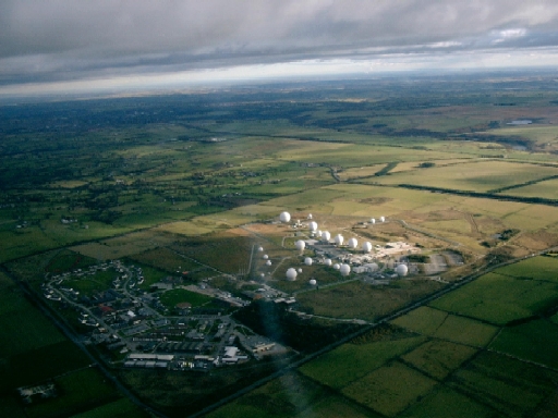
Aerial view from the north west of RAF
Menwith Hill
Photo
courtesy of www.fas.org
During
the Cold War, Menwith Hill was legitimately used as an early warning station
- linked to
RAF
Fylingdales - to track ballistic missiles. RAF Fylingdales is not shown
on 1:50000 scale OS maps.
You have to go to the 1:25000 scale OS map to finally reveal
RAF
Fylingdales and it is actually on top of Snod Hill rather than Fylingdales
Moor, but the name "RAF Snod Hill" just wouldn't have worked somehow!
It is curious that, since the end of the Cold War, Menwith's "golf ball"
radomes have actually multiplied like rabbits. The old "golf balls" at
Fylingdales were dismantled several years ago, to be replaced by state of
the art Phased Array Radar (PAR) units. The three-sided concrete plinth,
upon which these PAR units are mounted, can clearly be seen on Multimap's
aerial
photo.
Nowadays,
Menwith
Hill is actually labelled on the latest OS maps as "Menwith Hill Camp",
making it sound like an innocuous barracks full of harmless squaddies. In
reality, Menwith Hill is used to intercept communications in conjunction
with GCHQ. Because it is illegal for GCHQ to spy on its own UK citizens,
this problem is circumvented by having the US owned Menwith Hill do the dirty
work for them. Because of this US control, British MPs trying to ask questions
in parliament about the base just come up against a brick wall.
On the subject of squaddies, just east of the Menwith camp, on the road into
Harrogate, there's the
Army
Foundation College. It is the centre for junior soldier induction training,
split between the sites of the old Uniacke Barracks (south of the road) and
Hildebrand Barracks (north) on Penny Pot Lane.
Interestingly, right next door to Menwith Hill, the DCSA have another base
which they refer to as
HMS
Forest Moor. It is responsible for routing communications for the Royal
Navy.
It has been widely suggested that both the DCSA and GCHQ have operatives
working on covert signals interception projects within
Chetwynd
Barracks at Chilwell near Beeston, Nottingham. At first sight though,
this base would apparently just be part of the Defence Storage and Distribution
Agency (DSDA) network. Chetwynd was also used as a major training and
mobilisation centre for the war in Iraq.
Other key DCSA communications facilities can be found at
Inskip,
near Preston in Lancashire, at
Anthorn
on the Solway Firth coast in Cumbria and at
Crimond
on Scotland's Aberdeenshire coast between Fraserburgh and Peterhead, next
to the
St.
Fergus North Sea Gas Terminal. Predictably, both of the DCSA Inskip and
DCSA Crimond sites are labelled "Disused Airfields" on 1:25000 scale OS maps!
Anthorn is not labelled at all, although it is a former Royal Naval Air Station
(RNAS) and now forms part of the network of communications sites tracking
the UK's Trident submarine fleet.
If the US Government wants to perform commercial espionage in Europe, then
it's easy - just use Menwith Hill. The scandal surrounding the Airbus contract
a few years ago, confirmed Menwith Hill's role in this murky world. The
communications involving the bidding process by the various companies vying
for the contract were intercepted by the NSA at Menwith Hill. The details
were passed directly to the US Government, who then made sure their own US
companies were furnished with this "insider knowledge". Thus, the US companies
mysteriously landed the contract!
In a court case involving women peace campaigners a few years ago, a blundering
British Telecom official accidentally revealed in open court that those nice
BT engineers had connected fibre optic cables into Menwith Hill from their
own communications site at nearby
Hunters
Stones. These cables are said to provide the Menwith Hill base with over
100,000 UK telephone lines. Worried? You should be!
British Telecom seems very keen to keep its chums in MI5 and GCHQ happy.
BT's massive research laboratory at
Martlesham
Heath, near Ipswich in Suffolk, routinely takes apart all new communications
equipment that is produced so that "spooks" know precisely how to hack into
them! At BT's "switching centre" located in the Shropshire town of
Oswestry,
GCHQ is handed phone tapping opportunities on a plate.
Menwith Hill does perform important work in counter-terrorism. The telephone
calls between the terrorists plotting the "9/11" (September 11th 2001) hijackings
were picked up by operatives at Menwith Hill. Tragically, by the time the
masses of data had been assembled, passed to GCHQ for analysis and decoded
by "spooks" at MI5, the World Trade Centre's Twin Towers and all their occupants
had been turned to dust.
An amazing revelation can be found by viewing Menwith Hill on the Old Maps
web site. The 19th century map shows that the base is built above large quarry
workings. Could it be that many of Menwith Hill's activities are buried
underground in secret blast-proof bunkers and tunnel networks? Just a
thought!
Another very important spy centre can be found at the unassuming location
of
Irton
Moor, near the quaint seaside town of Scarborough. Back bench MPs in
successive governments have failed gloriously in trying to find out precisely
what goes on at this base, which MI5/6 operatives refer to as simply
"Scarborough". The
1:25000
OS map gives the full detail and labels it with the rather romantic title
"Wireless Station". It dates back to the very early pre-WWII days of GCHQ,
when that was known as the Government Codes and Ciphers School (GC&CS).
Irton Moor is sometimes referred to as a Composite Signals Organisation (CSO)
station.
The CSO has two other important outposts. One is on the rugged coastline
of Cornwall, just south of
Morwenstow
at Lower Sharpnose Point near Bude. This "Wireless Station" provides extra
intercept capability for GCHQ. Go to Multimap's site to view the
aerial
photo of GCHQ/CSO Morwenstow.
The other CSO site is deep inside English cider country, south of Taunton,
Somerset, at the tiny hamlet of
Culmhead
near Churchstanton and has been supposedly closed down. Again, this "Wireless
Station" has provided additional intercept capacity for GCHQ. Go to Multimap's
site to view the
aerial
photo with map overlay of GCHQ/CSO Culmhead. The address search facility
on the Old Maps web site discreetly lists the secret base as simply "Cipher
House, Culmhead, Taunton"!
All the CSO sites at Irton Moor, Morwenstow and Culmhead are inextricably
entwined with the US Government's NSA.
Finally, let's look at two of the UK's most secretive research laboratories
at
Fort
Halstead and
Porton
Down.
These two bases are part of the Defence Science and Technology Laboratory
(DSTL) network. Certain other research facilities, which have been transferred
to the commercial sector, have been collected together under the umbrella
organisation QinetiQ - pronounced "kinetic". As mentioned earlier, DSTL and
QinetiQ were formed in July 2001 out of the old Defence Evaluation and Research
Agency (DERA), which controlled all of the UK's MoD test ranges and research
establishments.
Many test veterans from the 1950s, seeking compensation from the Government
for their illnesses, believe they were stationed at the Germ Warfare research
facility at Porton Down, when in fact they were based at the neighbouring
Defence Nuclear, Biological and Chemical Centre (DNBCC) at
Winterbourne
Gunner. It was known formerly as the Joint School of Chemical Warfare
and is marked on maps as simply "barracks". The test ranges on the land to
the east of these sites are marked on all maps as Danger Zones.
On its official website, the Government announces that, "unfortunately, records
at Winterbourne Gunner were routinely destroyed some years ago".
Almost within walking distance of both Porton Down and Winterbourne Gunner,
you'll find the UK's miniaturised answer to America's Edwards Air Force Base
and Area 51 at
Boscombe
Down airbase, where all the RAF's new toys are put through their paces
and where US "black projects" are also tested and evaluated. Although modest
by US standards, it's no accident that it boasts one of the longest military
runways in the UK.
Boscombe Down is larger than the neighbouring town of Amesbury and is also
close to the Army's massive training ranges on Salisbury Plain. Local UFO
clusters were probably explained by regular visits by the top secret F-117
stealth aircraft during its development phase, rather than the excessive
consumption of particularly potent Wiltshire ale at Midsummer Solstice parties
being held at prehistoric
Stonehenge,
just a few miles to the north west!
Another contender for longest UK military runway is
RAF
Machrihanish at Campbeltown on the Mull of Kintyre in Scotland, which
was also rumoured to be used for the testing of the top secret F-117 stealth
fighter. Machrihanish's beachside main runway - over 3km long - is unusual
in that it runs west-east and allows aircraft to approach from over the Atlantic
Ocean without first going over many residential areas.
The Kintyre peninsula was made famous by former resident Paul McCartney's
song lamenting the mist rolling in off the sea.
A more sinister form of fame was created on 2nd June 1994 when an RAF Chinook
helicopter, carrying the UK's and Northern Ireland's upper echelons of military
and secret service staff, crashed in poor weather near Machrihanish airfield
whilst on its way from Belfast to a meeting on anti-terrorism at
Fort
George near Inverness.
An initial RAF Board of Inquiry was quick to conveniently conclude that "pilot
error" was the cause. However, rumours have persisted ever since that the
helicopter was caught in the jet wake of a hypersonic US "black project"
experimental aircraft. An alternative (but less sexy) explanation could be
a failure of the engine management software, which the MoD would have obviously
wanted to cover-up.
A
COPYRIGHT ©
2003-2004, Alan Turnbull
A Pagliacci
Production
