[Sample photos and captions]

9/12/2001 - Somerset Crash Site.
Source

9/22/2001 - Somerset Crash Site - The FBI investigation of the crash site
is
almost complete.
Source

9/22/2001 - Somerset Crash Site.
Source
10 September 2002. Updated with new aerial photos. See crash site and investigation photos by the Pennsylvania Department of Environmental Protection:
http://www.dep.state.pa.us/dep/emergency/pictures.htm[Sample photos and captions]
9/12/2001 - Somerset Crash Site. Source
9/22/2001 - Somerset Crash Site - The FBI investigation of the crash site is
almost complete. Source
9/22/2001 - Somerset Crash Site. Source
6 September 2002. One of the
Assassination Eyeball
series.
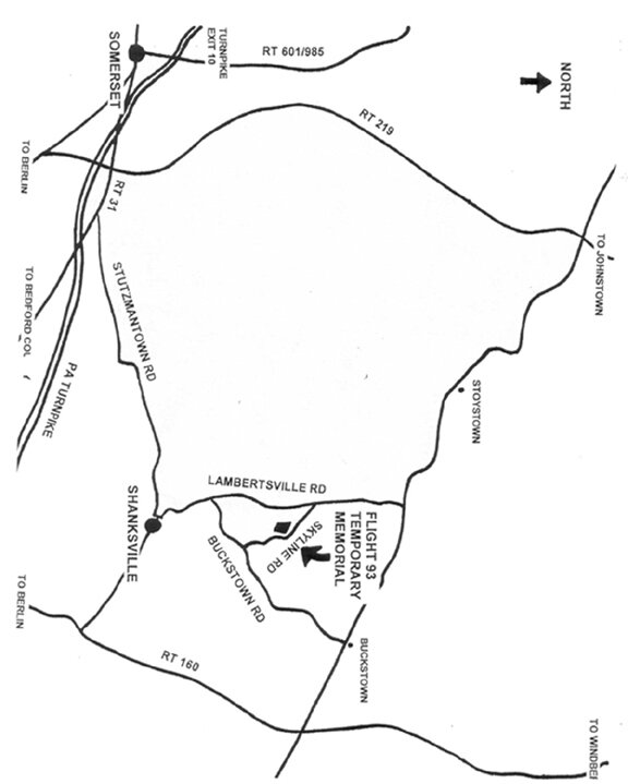
Source of maps and photos: Mapquest.com
(color) and TerraServer
USGS (monochrome).
Flight 93 crash site coordinates: 40N03.291, 78W54.723, taken from:
http://www.flt93memorial.org/
Aerial photos show the Flight 93 crash site in April 1994 when it was being reclaimed from a strip mining site. Neither Mapquest nor Terraserver have aerial photos of the post-crash site. Compare to aerial photos of the WTC and the Pentagon assassination sites on August 2, 2002:
http://www.digitalglobe.com/images/qb/manhattan_ground_zero_col080202_dg.jpghttp://www.digitalglobe.com/images/qb/pentagon_col080202_dg.jpg
Mapquest maps show the site with roads around the site in their present configuration, with Sky Line Road now crossing the reclaimed mining site. The Flight 93 temporary memorial site is on Sky Line Road near the red star.
A comparative impact study of the three killing fields, "Seismic Observations during September 11, 2001, Terrorist Attack:"
http://www.mgs.md.gov/esic/publications/download/911pentagon.pdf[Excerpt]

For the President's attendance at Flight 93/September 11 memorial services a no-fly zone has been set by the FAA:
http://www.faa.gov/ntap/SPECIALNOTAMS/Special%20Interest%20Notams.htm#!FDC 2/9366(Issued September 5, 2002)
!FDC 2/9366 ZOB PA.. FLIGHT RESTRICTIONS SOMERSET, PA. PURSUANT TO 14 CFR SECTIONS 91.141, FLIGHT RESTRICTIONS IN THE PROXIMITY OF THE PRESIDENTIAL AND OTHER PARTIES, AND 99.7 SPECIAL SECURITY INSTRUCTIONS. EFFECTIVE 0209111545 UTC (SEPTEMBER 11 AT 1145 LOCAL) UNTIL 0209111830 UTC (SEPTEMBER 11 AT 1430 LOCAL). EXCEPT FOR MILITARY, LAW ENFORCEMENT, AND MEDICAL/LIFEGUARD AIRCRAFT, THOSE PARTS 121, 125, AND 129 OPERATIONS THAT MEET TSA SECURITY REQUIREMENTS, AND PARTS 91/135 AIRCRAFT ON AN IFR FLIGHT PLAN; ALL AIRCRAFT OPERATIONS ARE PROHIBITED WITHIN A 30 NAUTICAL MILE RADIUS OF 4002N/07855W (THE INDIAN HEAD/IHD/VOR/DME 086 DEGREE RADIAL AT 21 NAUTICAL MILES) AT AND BELOW FL 180, UNLESS AUTHORIZED BY ATC.
|
 Source |
 |
 |
 |
 |
 |
 |
 |
 |
 |
 |
 USGS photo 20 Apr 1994 Dark scar is 1994 earthwork, near the crash location. |
 USGS topo 1 Jul 1995 |
 USGS photo 20 Apr 1994 Dark scar is 1994 earthwork, near the crash location. |
 USGS photo 20 Apr 1994 Dark scar is 1994 earthwork, near the crash location. FBI photo from http://www.bartcop.com/fl93-1.jpg |
