|
|
|
This file is available on a Cryptome DVD offered by
Cryptome. Donate $25 for a DVD of the Cryptome
10-year archives of 35,000 files from June 1996 to June 2006 (~3.5 GB). Click
Paypal or mail check/MO made out to John Young, 251 West 89th Street, New
York, NY 10024. Archives include all files of cryptome.org, cryptome2.org,
jya.com, cartome.org, eyeball-series.org and iraq-kill-maim.org. Cryptome
offers with the Cryptome DVD an INSCOM DVD of about 18,000 pages of
counter-intelligence dossiers declassified by the US Army Information and
Security Command, dating from 1945 to 1985. No additional contribution required
-- $25 for both. The DVDs will be sent anywhere worldwide without extra
cost. |
27 November 2006. Update with Google and Mapquest aerials.
DoD 3150.8-M, "Nuclear Weapon Accident Response Procedures (NARP) ", 2/2005
http://www.dtic.mil/whs/directives/corres/pdf/315008m_022205/315008m.pdf
(342 pages, 3.5MB)
Medical Management of Radiological Casualties Handbook
http://www.afrri.usuhs.mil/www/outreach/pdf/2edmmrchandbook.pdf
24 August 2003
http://www.dtic.mil/whs/directives/corres/pdf/31508m_1299/p31508m.pdf (now
dead; see 2005 edition above)
Nuclear Weapon Accident Response Procedures (NARP) Manual
![[Image]](narp-01.jpg)
This manual has been developed by the Defense Threat Reduction Agency (DTRA)
under the authority of the Department of Defense (DOD) Directive (DODD) 3150.8,
DOD Response to Radiological Accidents, June 13, 1996, and supersedes DOD
Manual 5100.52-M, Nuclear Weapon Accident Response Procedures (NARP) Manual,
September 4, 1990.
This manual applies to the Office of the Secretary of Defense (OSD), the
Military Departments (including the U.S. Coast Guard when it is operating
as a Military Service in the U.S. Navy), the Chairman of the Joint Chiefs
of Staff (CJCS), the Combatant Commands, the Defense Agencies, other Federal
organizations when operating with DOD, and the DOD Field Activities (hereafter
referred to collectively as "the DOD Components"). The term "Services," as
used herein, refers to the U.S. Army, Navy, Air Force, and Marine Corps.
This manual is effective immediately (its use is mandatory by all DOD
components).
The NARP provides Combatant Commanders, Services, Response Task Force (RTF)
Commanders and Initial Response Force (IRF) Commanders with the information
necessary to understand the overall response concept, the role of the IRF
and RTF, the relationship of the IRF, RTF, and DOD to other Federal agencies.
This manual also provides guidance in conducting site remediation activities
following an accident involving a nuclear weapon in DOD custody or other
types of radiological accidents or incidents. It assumes that a radiological
release of some magnitude has occurred and that some remediation of the affected
land is required. It is not intended as a comprehensive document to encompass
all aspects of site remediation, but seeks to define a process by which response
organizations may effectively face the challenge of site remediation.
This manual provides a notional RTF organization, identifies applicable DOD
publications and resources used in response efforts, describes the policies
and responsibilities outlined in these publications, identifies specific
radiological information available in other publications, and provides a
basis for Combatant Command and RTF planners to develop detailed plans tailored
to each Theater of Operations and RTF area of operations. It provides a framework
for DOD elements responding to non-DOD radiological events. This manual also
describes the substantial resources other Federal agencies make available
to assist in the response effort.
This manual will be widely disseminated and made available to all commanders
and staff who are tasked to primarily respond to a nuclear weapon accident
and, secondly, to radiological accidents or incidents. It should serve as
a guide for more detailed planning by response forces and will be used to
improve training and exercise programs.
BENT SPEAR. A DoD term used to identify and report a nuclear weapon significant
incident involving a nuclear weapon/warhead, nuclear component, or vehicle
when nuclear loaded.
BROKEN ARROW. A DoD term to identify and report an accident involving a nuclear
weapon, warhead, or nuclear component.
DULL SWORD. A team used in DoD to identify and report a nuclear weapon safety
deficiency.
EMPTY QUIVER. A reporting term used by DoD to identify and report the seizure,
theft, or loss of a U.S. nuclear weapon.
FADED GIANT. A reporting term to identify an event involving a nuclear reactor
or radiological accident.
Radiological Event. Used to refer to any accident, incident, or
significant incident involving radioactive materials in DoD custody or any
Improvised Nuclear Device (IND) incident involving other materials. This
includes BROKEN ARROW, BENT SPEAR, and EMPTY QUIVER.
20 June 2002. Add Ellsworth AFB and Loring AFB. Thanks to M, see related
nuclear missile fields associated with some of these bases:
http://www.angelfire.com/tx/missileaway/
From
http://www.nrdc.org/nuclear/tkstock/p53-94.pdf
A Defense Special Weapons Agency (DSWA) funded and Air Combat Command sponsored
force-on-force exercise, called “Mighty Guardian 94” was held at
Ellsworth AFB in May 1994. The exercise showed that increased physical delay
is crucial in resource allocation and security police training and tactics
for the security of nuclear weapons. On December 30, 1994, the Chief of Staff
of the Air Force signed a memorandum, concerning “Nuclear Storage Area
Security Improvements,” and emphasized the need to enhance the security
facilities and tactics used to secure nuclear weapons and urged units with
WSAs to “find effective and affordable ways to address the problems.”
This has led to improved anti-terrorism security measures at nuclear facilities
throughout the U.S.
18 June 2002. Add Fairchild AFB and number of nuclear weapons at each base.
M writes:
You published:
>Bangor, WA, Naval WSA (portion; big color photo at link)
>Coordinates:
>47N 43' 05", 122W 42' 53"
>5,285,000.0, 521,400.0
Alas, you are missing the UTM longitude and latitude zone. Also, to
be strictly pedantic about it, the easting should come before the
northing. So the above entry ought to read:
>10T 521400 5285000
However a more compact notation which allows for variable precision is the
"military grid reference system" (MGRS), which has recently become the "United
States National Grid" (USNG). If you have seen gun-sight footage from helicopters
or bomb-site stuff from planes, you may have noticed the MGRS references
of the platform near one edge of the display.
In that form, the above becomes:
10TET214850
Though some like to add spaces:
10T ET 214 850
Anyways, in this form, your entire list is:
WSA BANGOR      10T ET 214 850
WSA BARKSD      15S VR 396 968
WSA CHARLE      17S NS 956 526
WSA DYESS       14S MA 222 888
WSA GFORKS      14T PU 213 109
WSA KINGSB      17R MQ 488 056
WSA KIRKLD      13S CU 624 746
WSA MALMST      12T VT 876 618
WSA MINOT       14U LU 289 645
WSA NELLIS      11S PA 836 138
WSA NORTHI      11S MS 792 168
WSA WARREN      13T EF 101 545
WSA WHITEM      15S VC 532 866
WSA YORKTN      18S UG 590 212
Suitable for entry into the weapon system of your choice! ;-)
If you want more challenging targets, you can try these [North Dakota missile
silos]:
N48o27.46' W102o24.48' [TerraServer URL]
N48o44.23' W102o19.65' [TerraServer URL]

[48N 12' 05", 102W 13' 39" TerraServer URL]
I found these by browsing around TerraServer with the hints from some online
maps of ICBM silos. Look for small, but bright, rectangles with some
whitish areas inside. Tedious work. Better to send a local out
with a GPS receiver. Perhaps a cartome community mapping project?
17 June 2002
To see more of these sites enter the coordinates at
TerraServer,
Advanced Find, or
MapQuest, Latitude
and Longitude.
See related US Nuclear Power Plants:
http://cryptome.org/npp/62npp-eyeball.htm
These show US nuclear weapons storage areas (WSAs) based on the report
Taking Stock: Worldwide
Nuclear Deployments 1998, by William M. Arkin, Robert S. Norris and
Joshua Handler, published in March 1998 by the
Natural Resources Defence Council. The
report emphasizes that the information on nuclear weapons is highly secret
and may be different from that described. Locations may have changed since
1998, the date of the report, as well as since the date of the photos below.
This covers weapons storage areas only, not those on naval vessels, in aircraft
and missile silos or overseas. The NRDC report describes the full range.
Source of base locations and weapons count only:
http://www.nrdc.org/nuclear/tkstock/p53-94.pdf
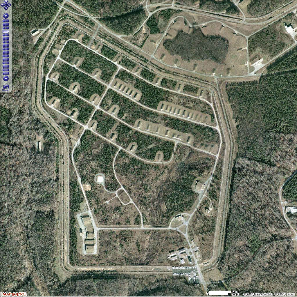
Photos and coordinates of the WSA within bases by Cryptome. Links are to
eyeballs of bases.
(TerraServer aerial
photos are all the same scale.)
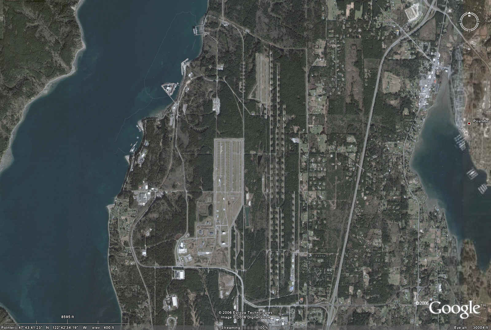
Bangor, WA, Naval WSA
Coordinates:
47N 43' 05", 122W 42' 53"
5,285,000.0, 521,400.0
Bangor, WA 1600
1600 W76/Trident I
|
| Google
 |
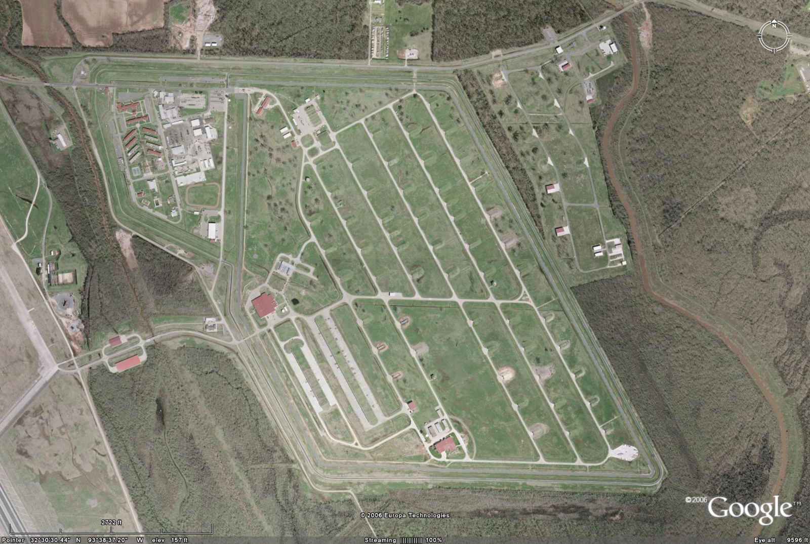
Barksdale AFB, LA, WSA
Coordinates:
32N 30' 25", 93W 38' 35"
3,596,800.0, 439,600.0
Barksdale AFB, LA 540
50 B61 Mod 7
90 B83
300 W80-1/ALCM
100 W80-1/ACM
|
| Google
 |
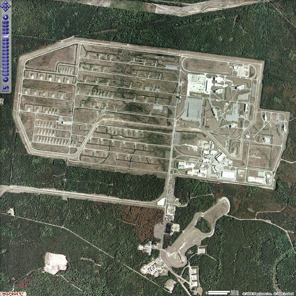
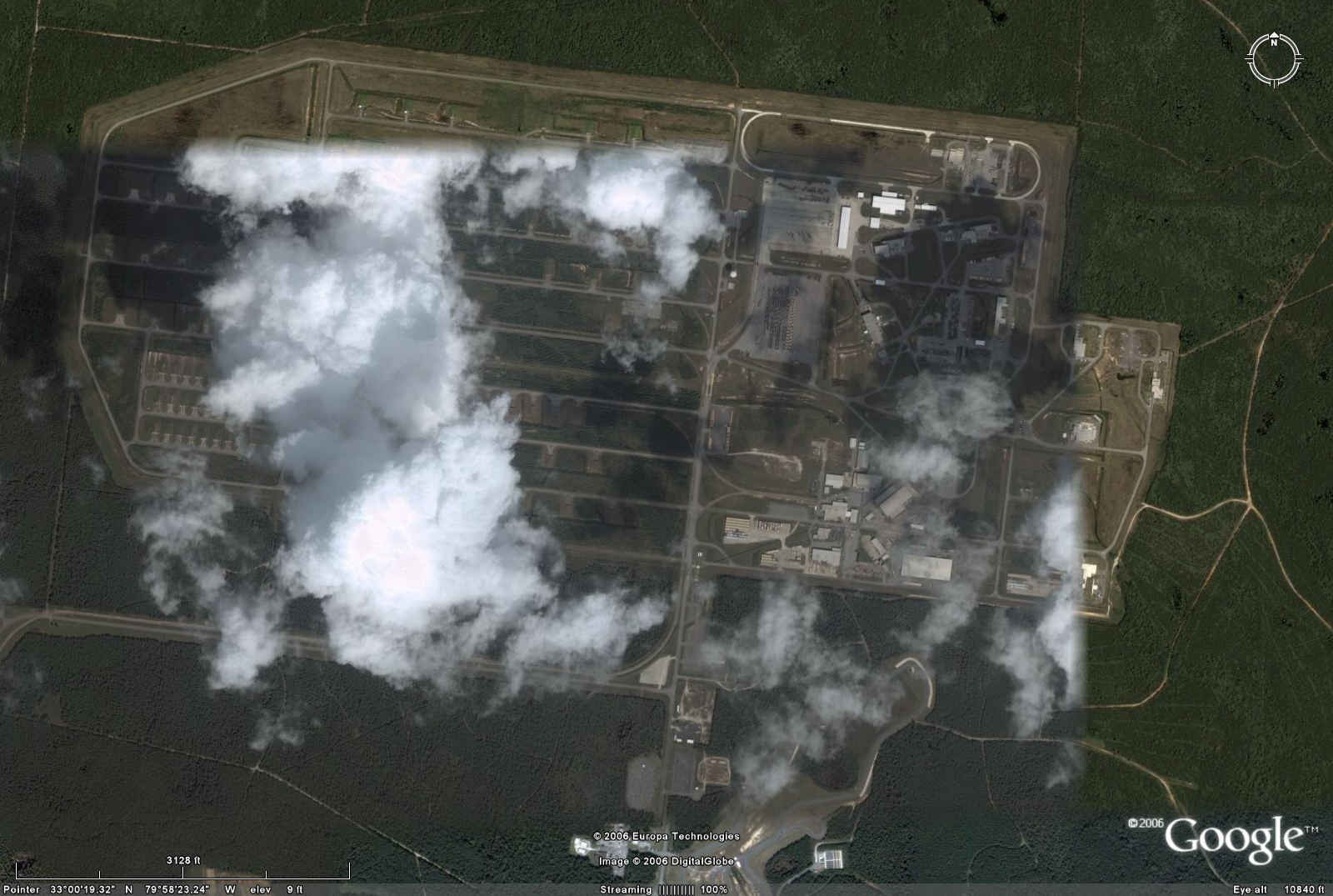
Charleston, SC, Naval WSA
Coordinates:
33N 00' 28", 79W 58' 36"
3,652,600.0, 595,600.0 |
| Mapquest
 |
| Google
 |
Dyess AFB, TX WSA
Coordinates:
32N 26' 01", 99W 49' 39"
3,588,800.0, 422,200.0 |
| Google
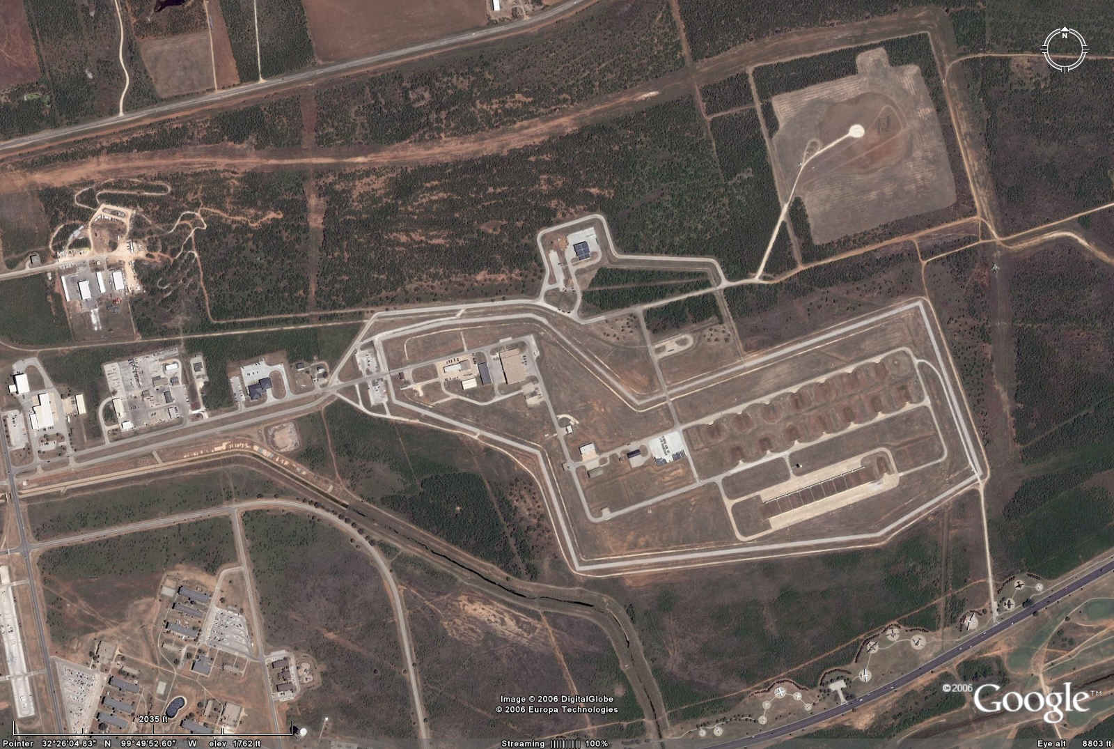 |
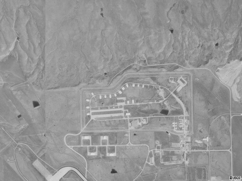
Ellsworth AFB, SD, WSA
Coordinates:
44N 09' 57", 103W 06' 33"
4,892,000.0, 651,200.0
Nuclear weapons 0 according to
http://www.nrdc.org/nuclear/tkstock/p53-94.pdf:
SOUTH DAKOTA no longer hosts nuclear weapons, with the deactivation of the
Minuteman II ICBM Wing at Ellsworth AFB and the 1996-97 conversion of the
28th Bomber Wing to conventional only B-1B missions. On September 13th 1996,
the 149th and last silo was blown up at Ellsworth, well ahead of schedule.
The 150th silo, and an associated underground launch control center were
nominated as National Historic Landmarks.
USGS photo 3 Apr 1997 |
 |
| Fairchild AFB, WA, WAS
Coordinates:
47N 36' 24", 117W 38' 19"
5,272,800.0, 452,000.0
Fairchild AFB, WA 85
25 B61 Mod 7
60 B83
|
| Google
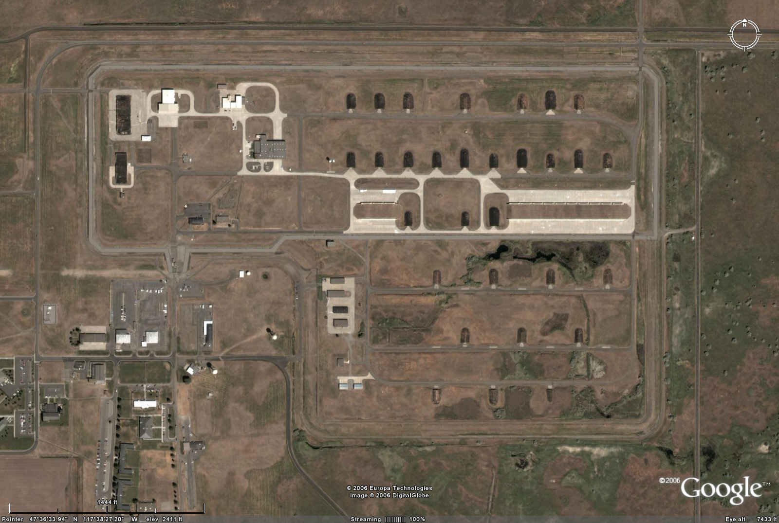 |
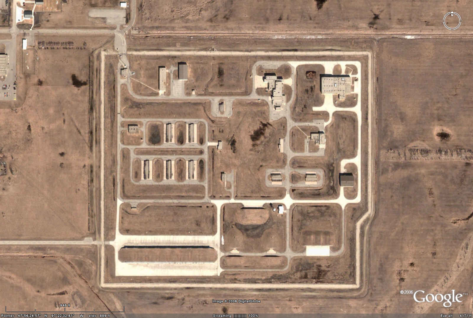
Grand Forks AFB, ND, WSA
Coordinates:
47N 56' 24", 97W 22' 33"
5,310,900.0, 621,300.0
Grand Forks AFB, ND 145
25 B61 Mod 7
60 B83
60 W78/Minuteman III
|
| Google
 |
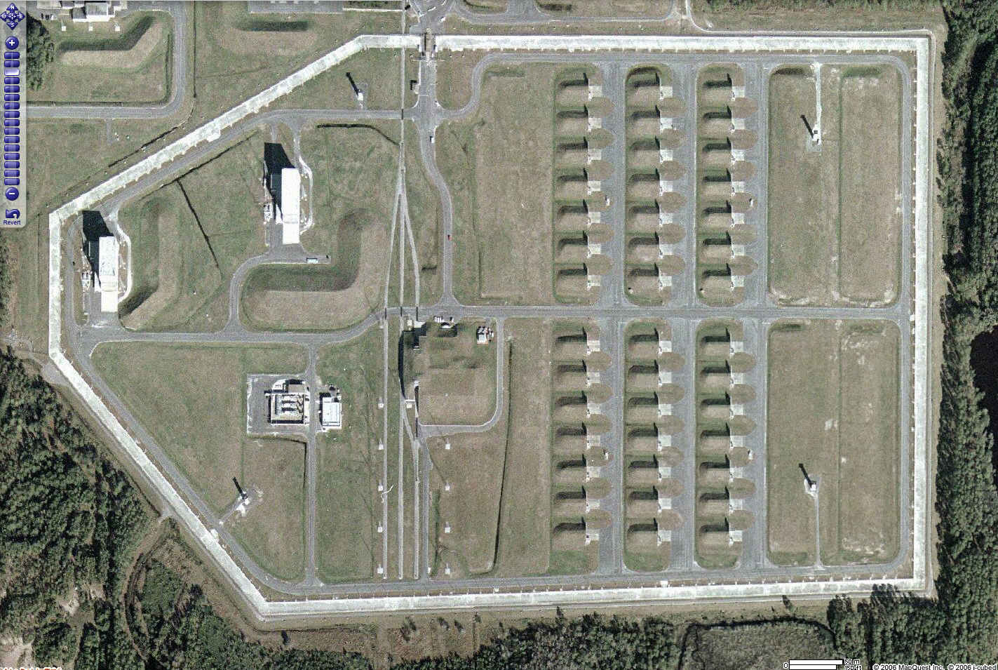
Kings Bay, GA, Naval WSA
Coordinates:
30N 46' 56", 81W 32' 06"
3,405,600.0, 448,800.0
Kings Bay, GA 2000
1600 W76/Trident I
400 W88/Trident II
|
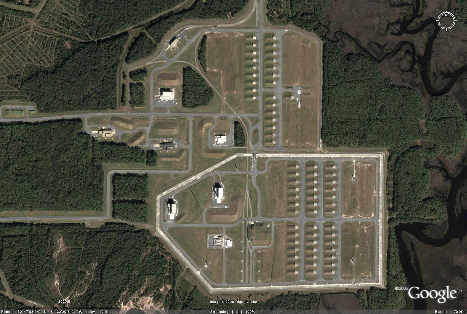 |
| Mapquest
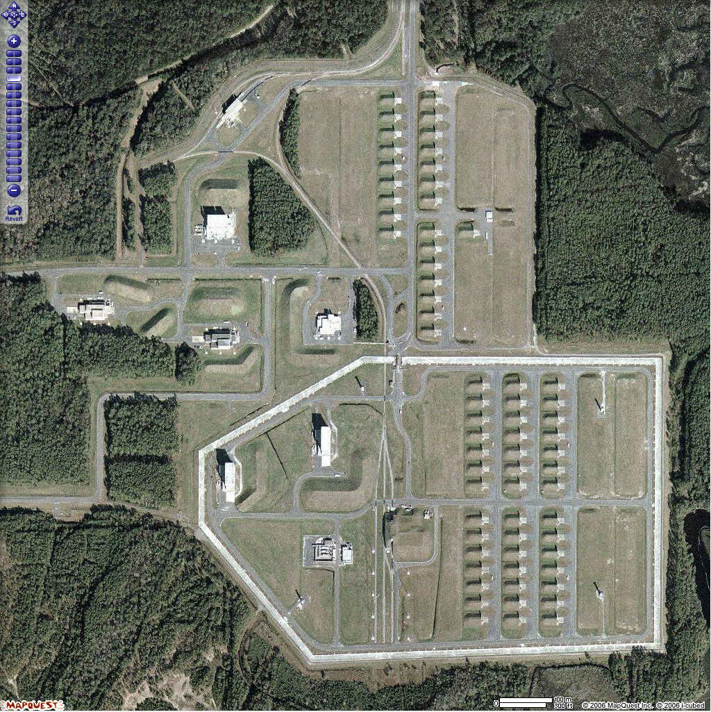 |
| Google
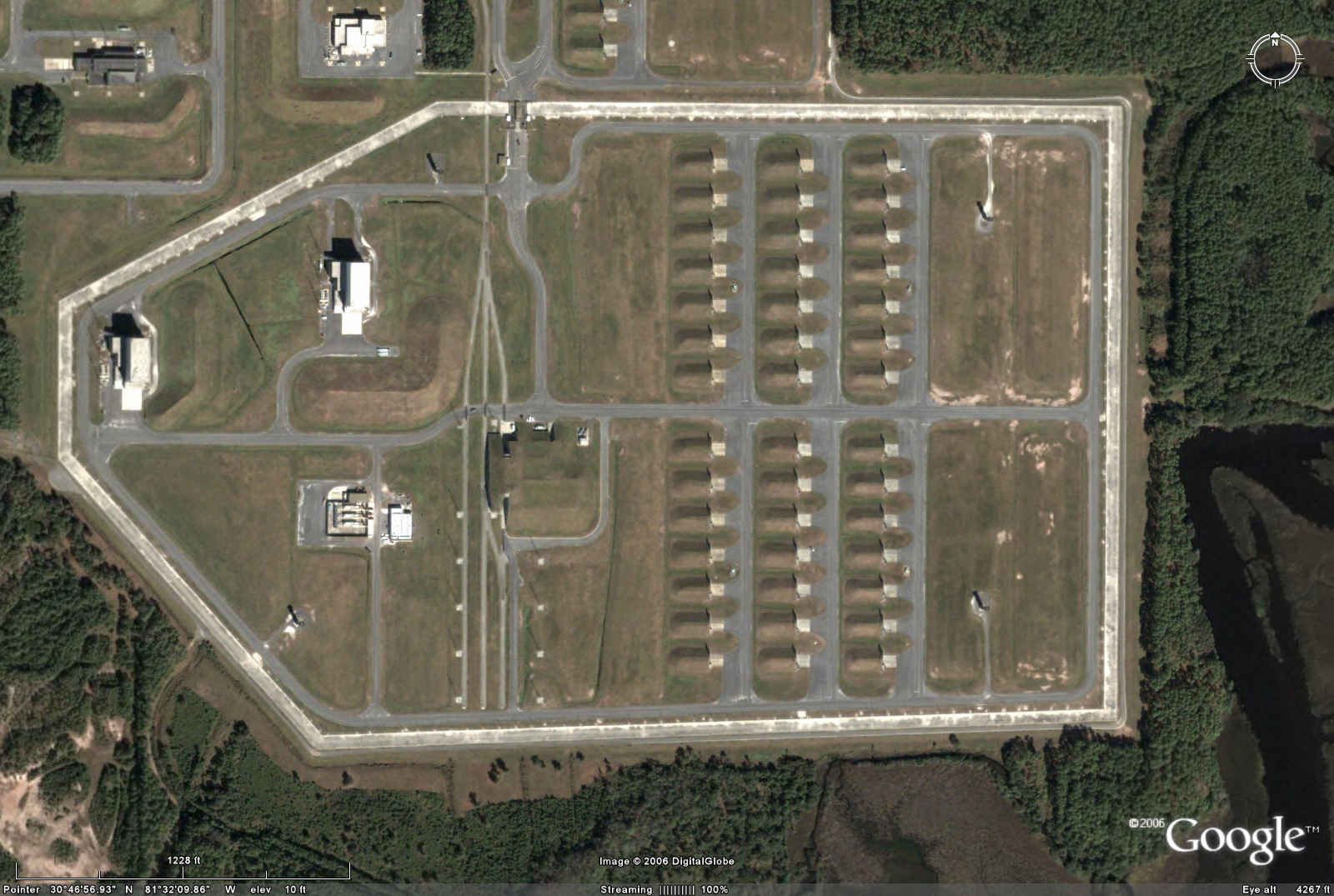 |
| Mapquest
 |
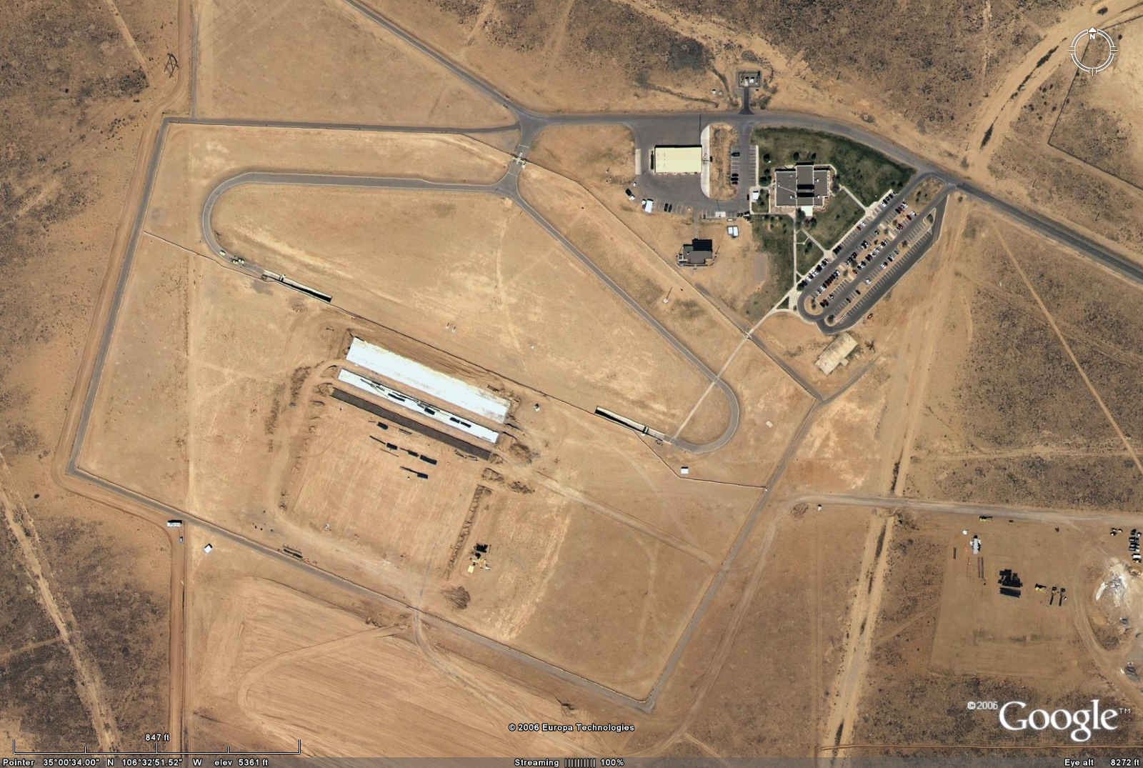
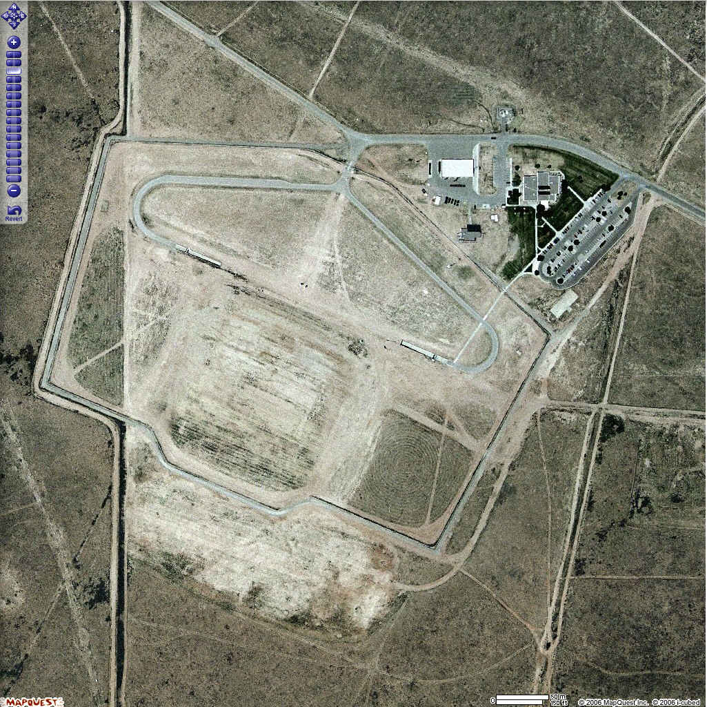
Kirtland Underground Munitions Storage Complex, NM
Coordinates:
35N 00' 17", 106W 30' 28"
3,874,600.0, 362,400.0
Kirtland AFB, NM 2450
85 B61 Mod 7
365 W80-1/ALCM
600 B61 Mods 3, 4, 10
450 W56/Minuteman II
550 W69/SRAM
400 W84/GLCM
|
| Google
 |
| Mapquest
 |
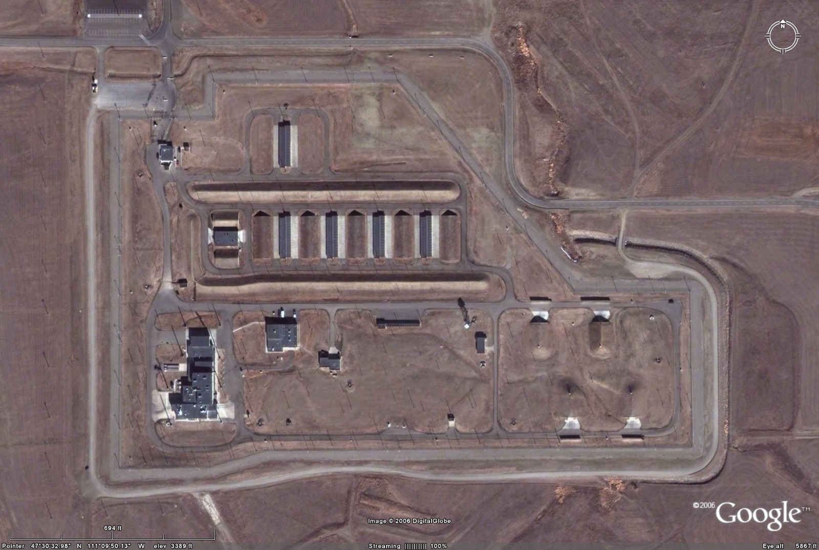
Malmstrom AFB, MT, WSA
Coordinates:
47N 30' 34", 111W 09' 53"
5,261,800.0, 487,600.0
Malmstrom AFB, MT 550
150 W62/Minuteman III
400 W78/Minuteman III
|
| Google
 |
|
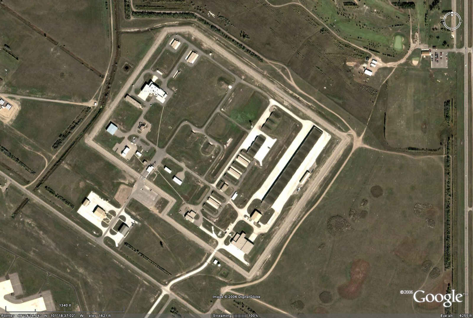
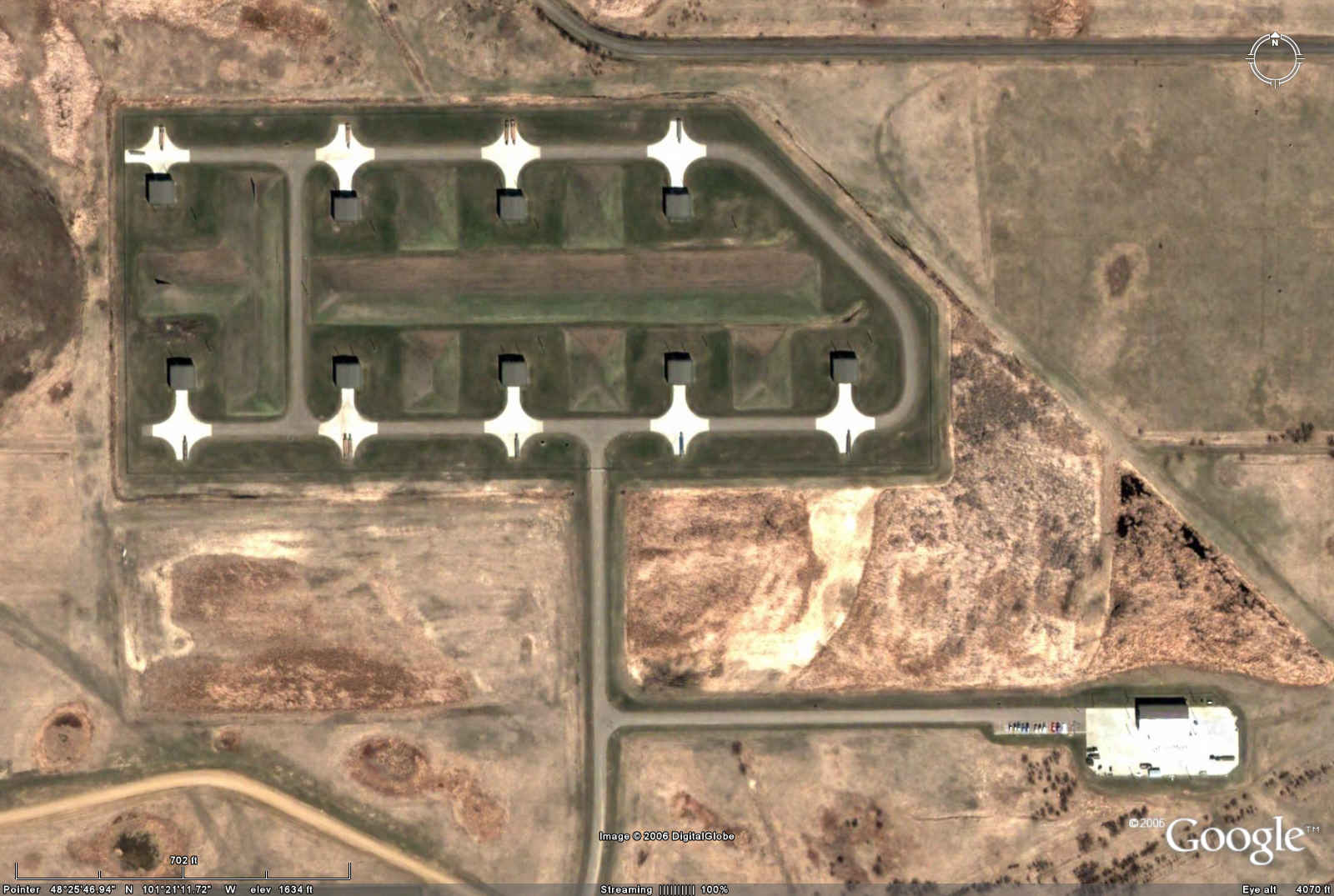
Minot AFB, ND, WSA
Coordinates:
48N 24' 37", 101W 18' 43"
5,364,500.0, 328,900.0
Minot AFB, ND 995
50 B61Mod 7
90 B83
100 W80-1/ALCM
300 W80-1/ACM
455 W78/ Minuteman III
|
| Google
 |
| Google
 |
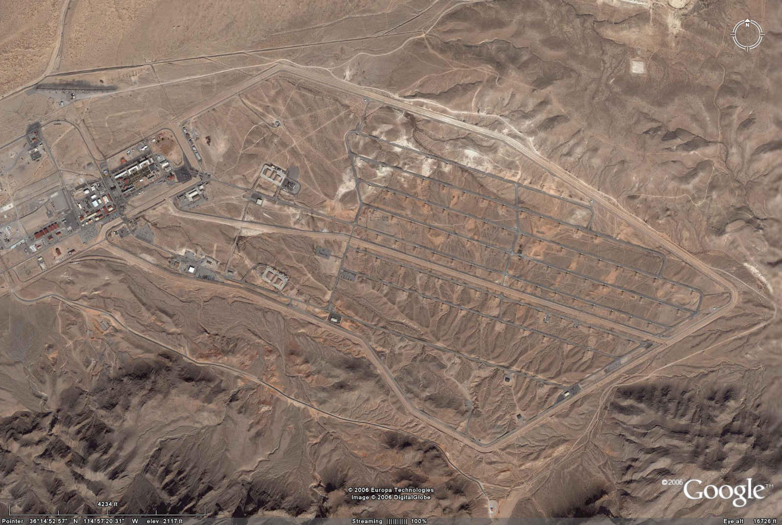
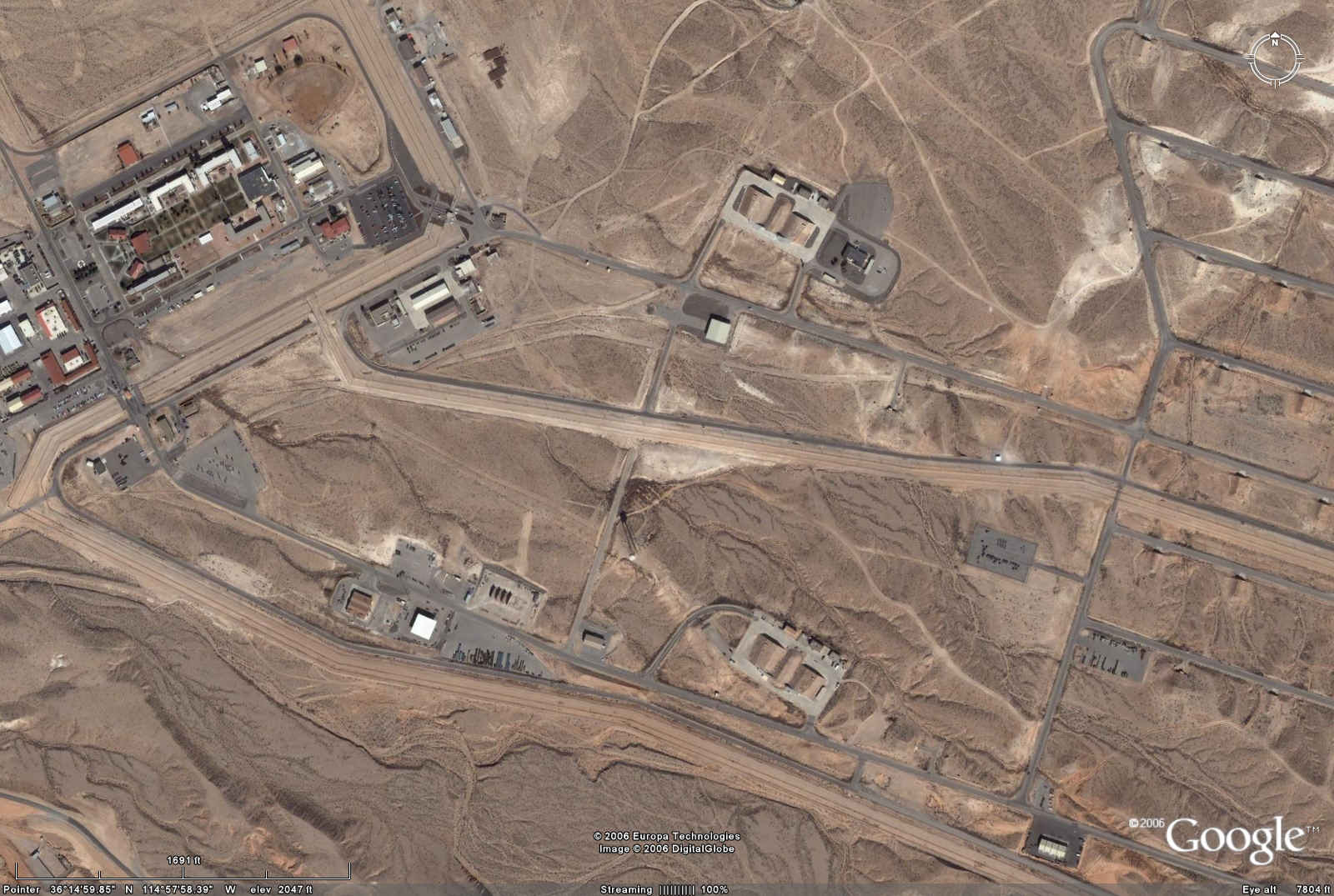
Nellis AFB, NV, WSA
Coordinates:
36N 15' 06", 114W 57' 24"
4,013,800.0, 683,600.0
Nellis AFB, NV 1300
175 B61 Mod 7
575 W80-1/ALCM
600 B61 Mods 3, 4, 10
|
| Google
 |
| Google
 |
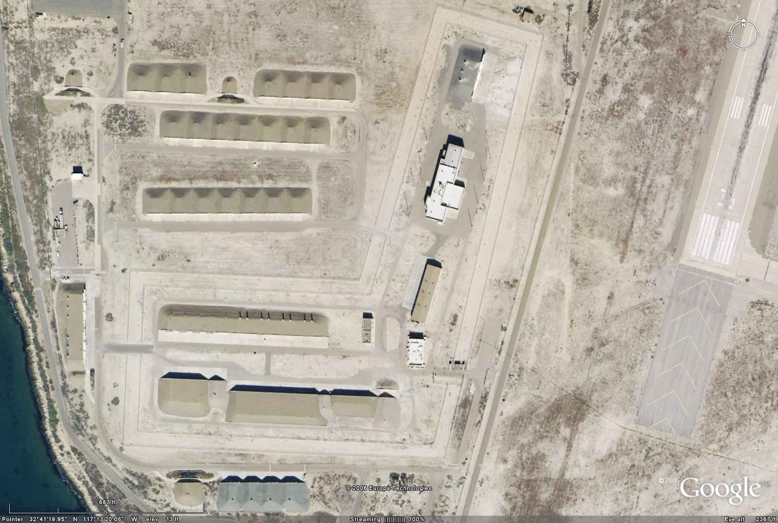
North Island, CA, Coronado Naval Air Station WSA
Coordinates:
32N 41' 19", 117W 13' 19"
3,616,800.0, 479,200.0
North Island NAS, CA 160
160 W80-0/SLCM
|
| Google
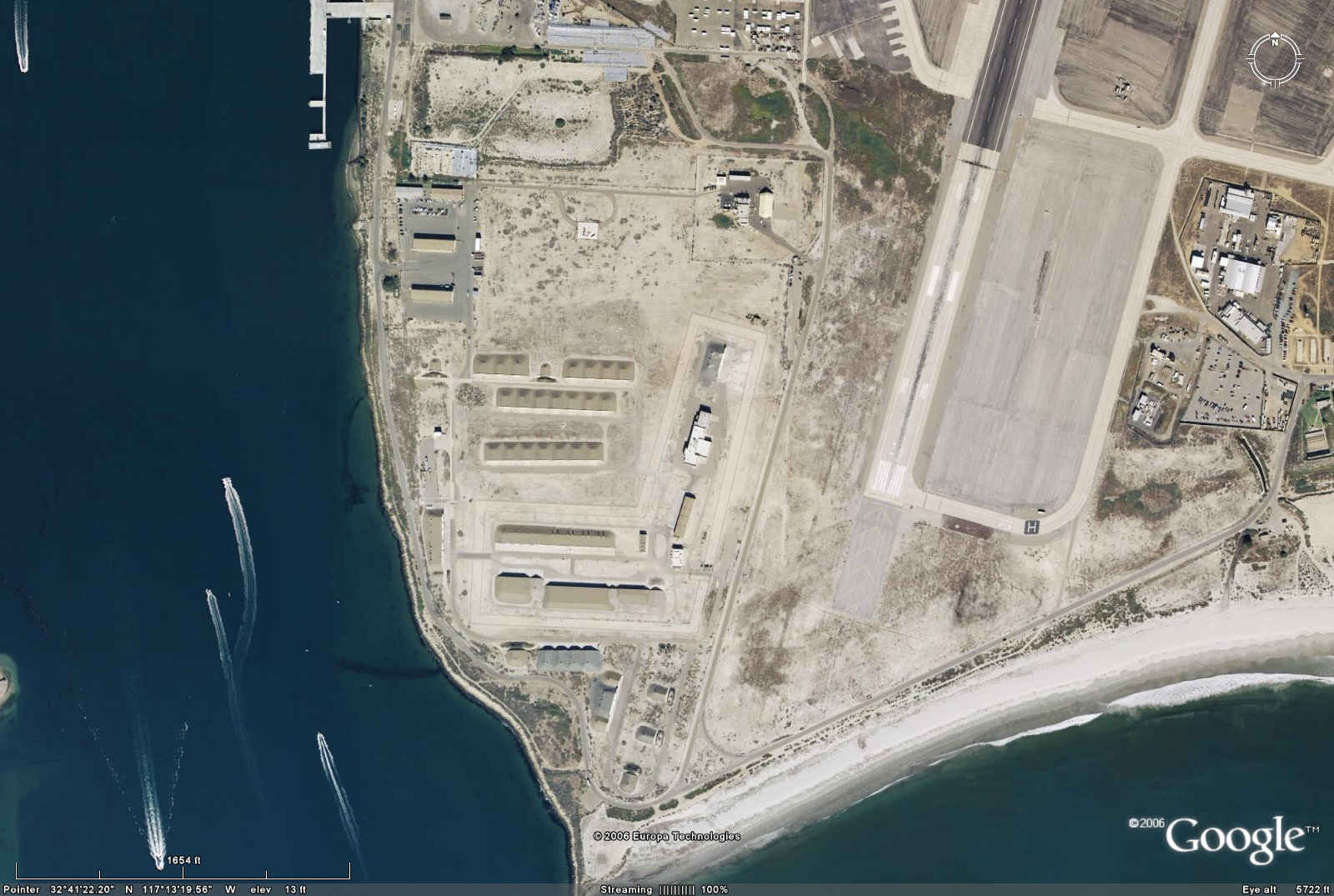 |
| Google This area does not appear to be secure and may not contain
nuclear weapons: there are two breaches in the double-security fence.
 |
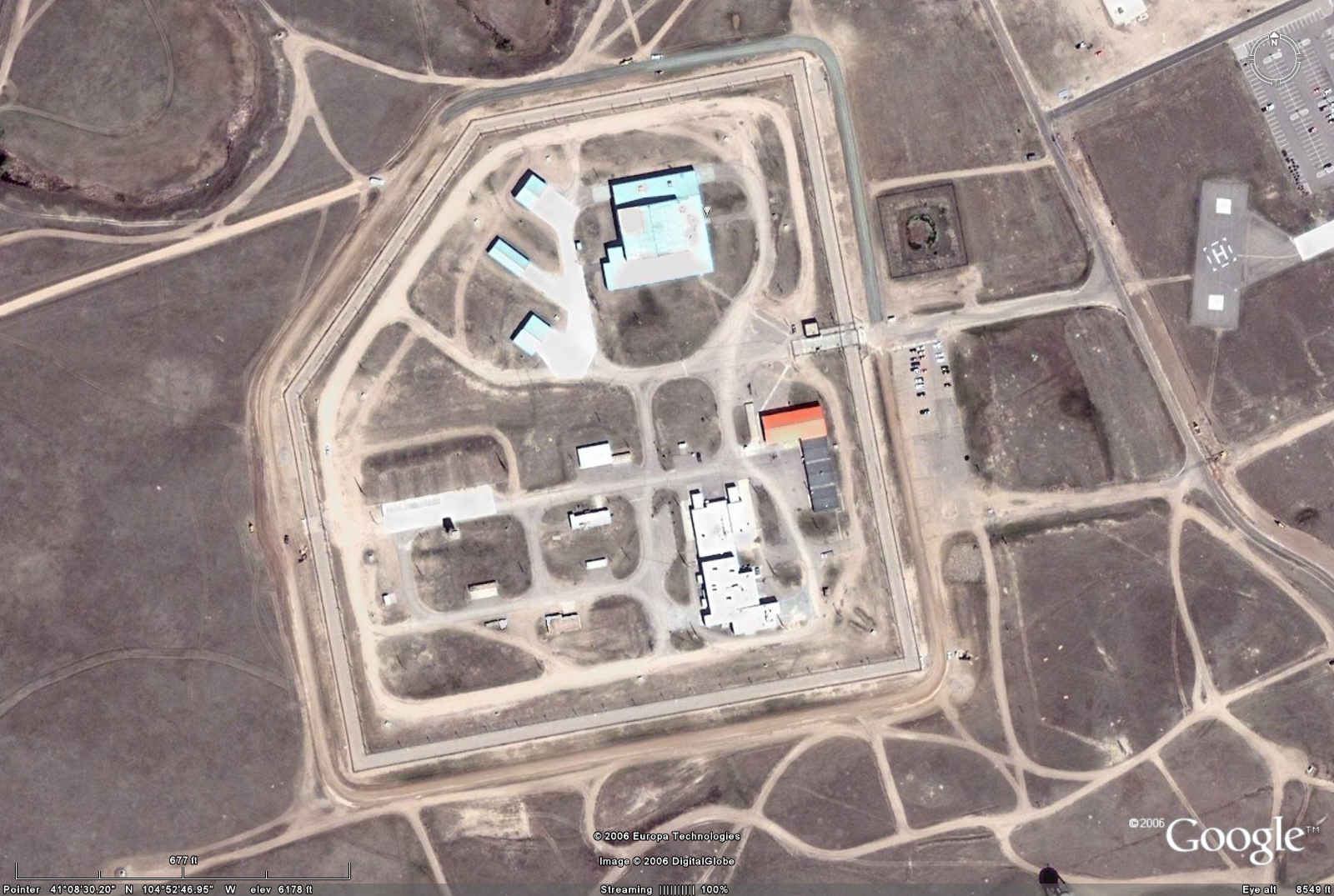
Warren AFB, WY, WSA
Coordinates:
41N 08' 30", 104W 52' 46"
4,554,500.0, 510,100.0
Warren AFB, WY, CO, NE 610
610 W62/Minuteman III
|
| Google
 |
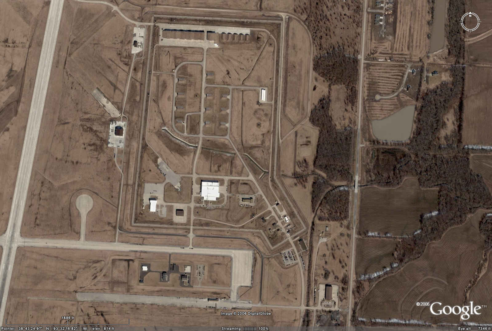
Whiteman AFB, MO, WSA
Coordinates:
38N 43' 36", 93W 32' 18"
4,286,600.0, 453,200.0
Whiteman AFB, MO 550
200 B61 Mod7
50 B61 Mod 11
300 B83
|
| Google
 |
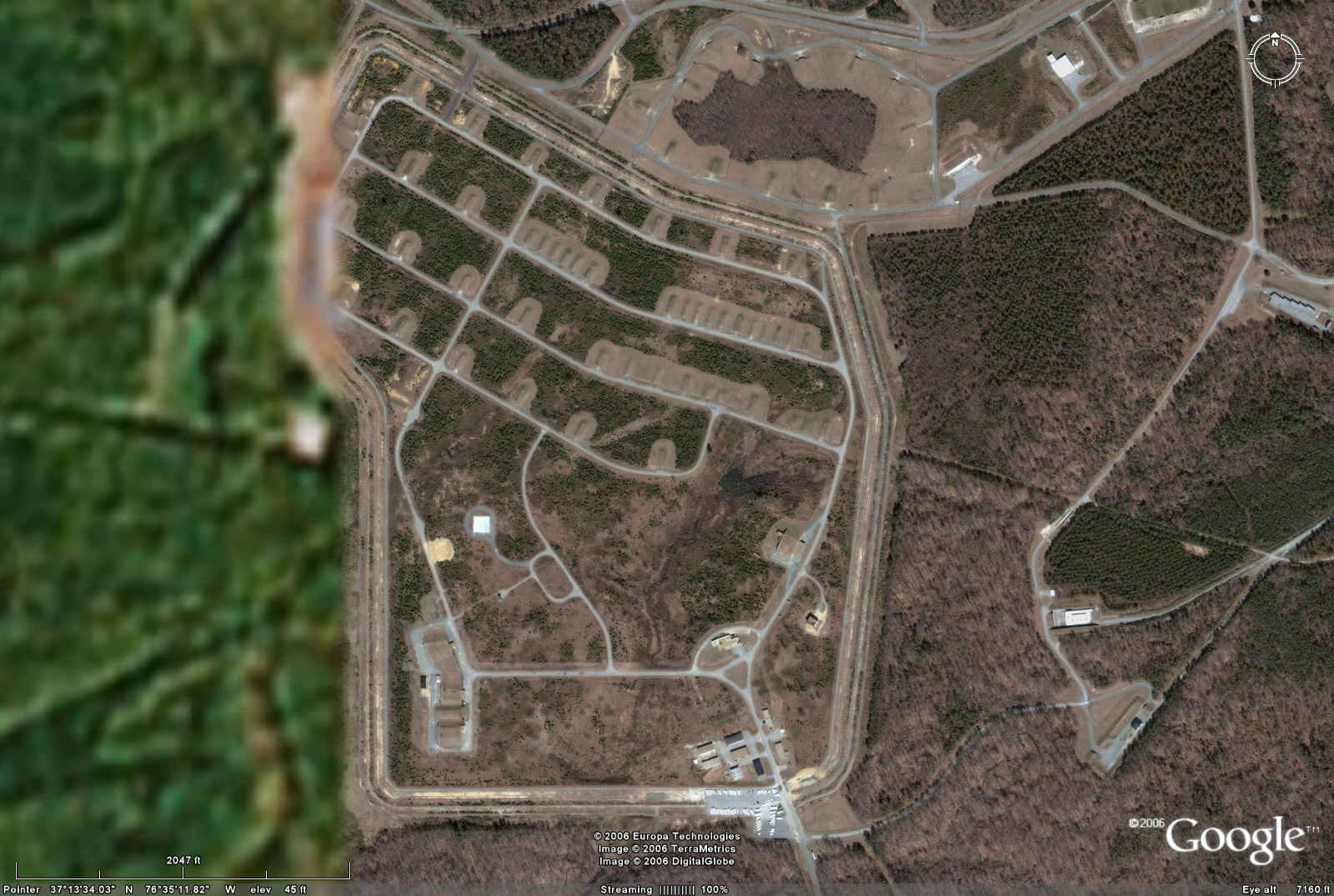
Yorktown, VA, Naval Weapons Station
Coordinates:
37N 13' 36", 76W 35' 21"
4,121,200.0, 359,000.0
Yorktown NAS, VA 160
160 W80-0/SLCM
|
| Google
 |
| Mapquest
 |