|
This file is available on a Cryptome DVD offered by Cryptome. Donate $25 for a DVD of the Cryptome 10-year archives of 35,000 files from June 1996 to June 2006 (~3.5 GB). Click Paypal or mail check/MO made out to John Young, 251 West 89th Street, New York, NY 10024. Archives include all files of cryptome.org, cryptome2.org, jya.com, cartome.org, eyeball-series.org and iraq-kill-maim.org. Cryptome offers with the Cryptome DVD an INSCOM DVD of about 18,000 pages of counter-intelligence dossiers declassified by the US Army Information and Security Command, dating from 1945 to 1985. No additional contribution required -- $25 for both. The DVDs will be sent anywhere worldwide without extra cost. | |||
13 March 2006. Add Google Maps aerial:
http://maps.google.com/maps?f=q&hl=en&q=olney,md&ll=39.210609,-77.106868&spn=0.007157,0.016758&t=k
15 February 2005.
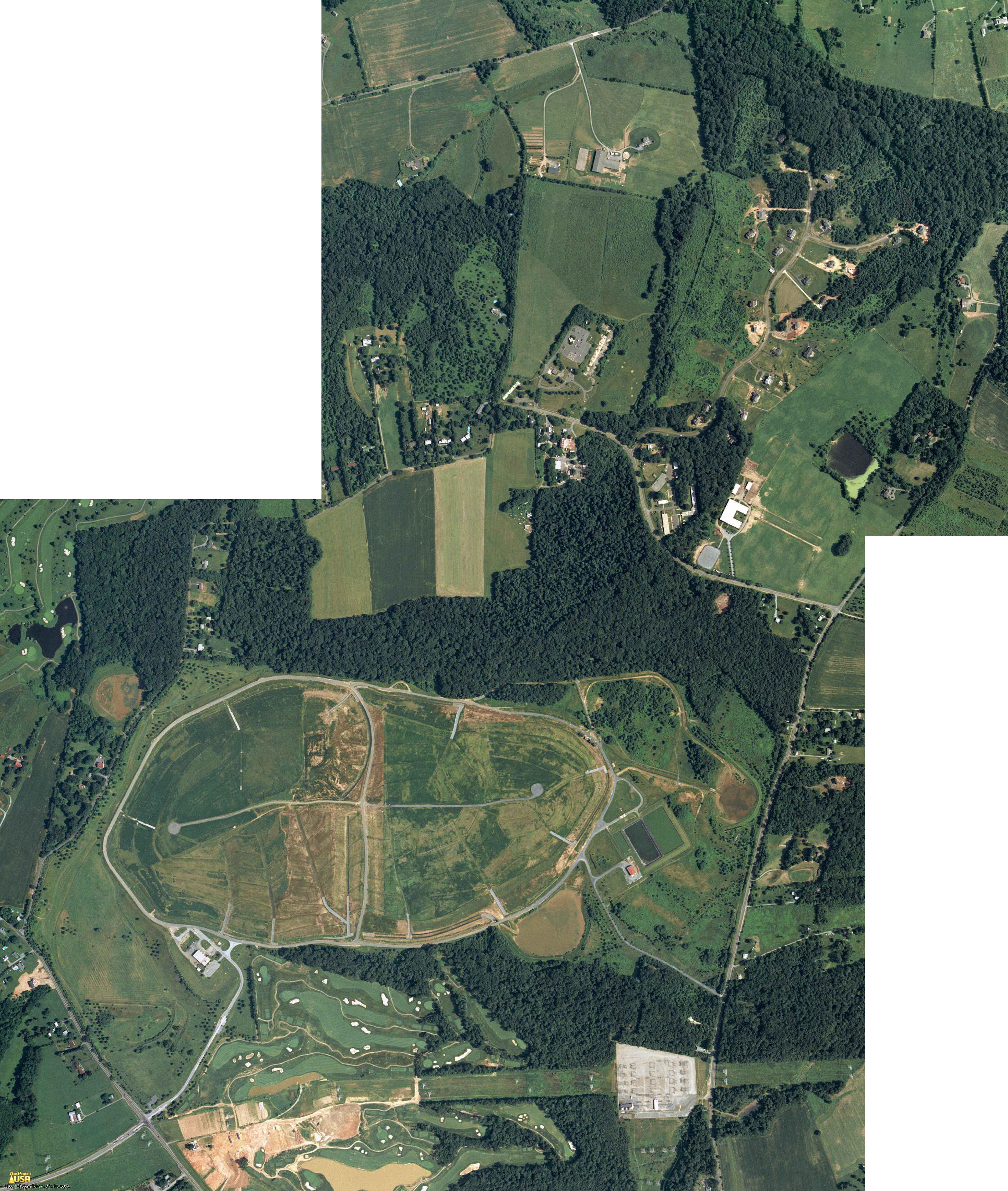
The oval-shaped facility at the bottom of the large photos below is the Oaks Landfill, a former garbage dump which has been prepared for capturing methane gas to generate electricity which is fed into the PEPCO system adjoining the landfill. A photo of a skateboarder in action at a paved drainage ditch of the landfill.
A Maryland Army National Guard facility is located at 5115 Riggs Road adjoining the FEMA facility at 5321 Riggs Road:
 Source |
A correspondent claims there are several extensive underground facilities
at this site in addition to the FEMA facility, and that the nearby PEPCO
substation likely provides power to them. Cryptome welcomes information on
these unidentified facilities:
jya@pipeline.com
It is a camouflage practice to locate highly sensitive underground military and governmental sites under benign-appearing locations, including hospitals, schools, churches, parks, forests, lakes and factories such as the continuity of government bunker formerly located under the Greenbriar Resort in Virginia.
11 February 2005.
M. writes:
I'm not sure about the accuracy of your information here.I was in the FEMA Olney Federal Regional Center back in the 1980's and it is not in the location shown on your webpage:
http://cryptome.org/fsc-eyeball.htm
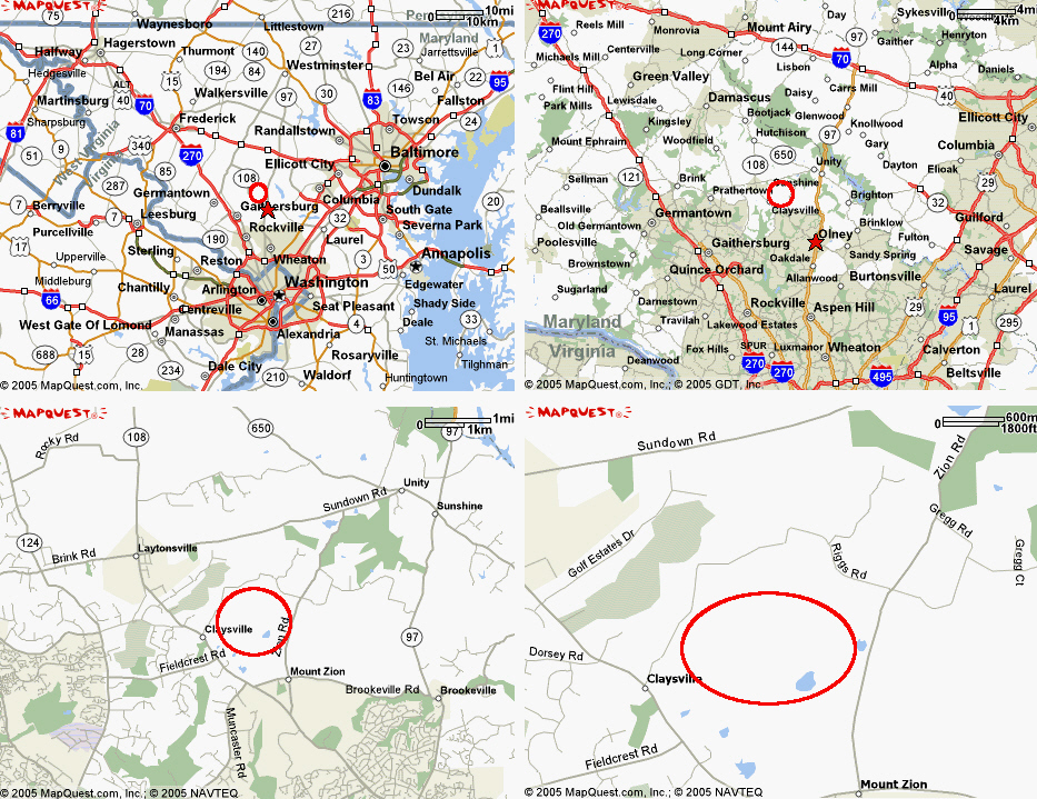
The FRC bunker is on the north side of Riggs Rd, not the south, on the site of a former Army or National Guard post (there may still be some NG activity there, but it is not an active base). I believe it was also at one time the site of a Nike air defense battery. The attached map shows the actual location.
This terraserver image shows the bunker:
http://www.terraserver.microsoft.com/image.aspx?T=1S=10&Z=18&X=1590&Y=21710&W=3&qs=%7cOlney%7cMD%7c
It is located under the rectangular parking lot in the center of the image (the parking lot is askew about 10 degrees off north). The entrance to the bunker is through a small sacrificial oval aboveground building seen on the left side of the parking lot. Riggs Rd is visible curving up from the bottom of the image, the driveway entrance to the bunker is just to the left of the vertical centerline of the image.
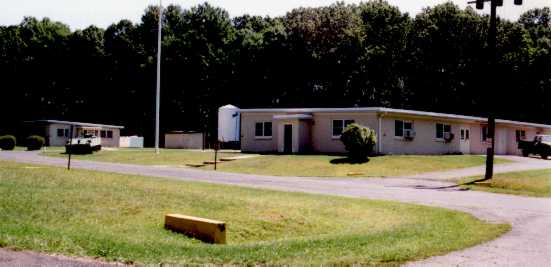
![[Image]](fsc-285.jpg)
The bunker is just a two-level cut and cover concrete bunker with the parking area on the roof. It is not of the scale of Cheyenne Mountain, Mt. Weather, or Raven Rock Mountain/Site R. That area has no terrain features suitable for a tunneled type of bunker. At the time that I was there, the Alternate Warning Center was in operation and manned 24 hours a day, and there was some minor data center operations, but the facility was nowhere near operating at full capacity. I have heard that some other agencies may have moved in since Sept. 11th, but do not have any more recent knowledge.
This type of bunker offers limited blast protection compared with a tunneled bunker such as the others mentioned above. It is comparable to any of the many larger AT&T underground main stations and probably has 100,000 or so square feet of area and similar blast and fallout protection.
I don't know what the large oval earthworks shown in the overhead imagery on your page shows, but it is located in a floodplain as shown on the various topo maps I have seen, so it may be some sort of water impoundment.
I don't claim to know everything about FEMA operations and it is entirely possible that there are other operations in the area, but this is the only known bunker facility in Olney and is the one that was known as the Olney Federal Regional Center and is the site of the Alternate Warning Center.
Also on the former Nike base:
http://ed-thelen.org/loc-m.htmlLocations of Former NIKE MISSILE SITES
W-93 Laytonsville/ Derwood
L - 5321 Riggs Rd ((P) MDArNG; unit unknown
[{Page, T} TerraServer ]
![[Image]](fsc-283.jpg)
[{Koch, M} Dec. 2002 - First of all, Laytonsville and Derwood aren't anywhere near each other. Although they're not in different parts of the state they're not close enough to possibly have anything to do with each other. The site is located in Olney. I know it's sometimes common to use the largest nearby town as an actual location instead of the nearest town but Olney is not only closer it's also larger. (two miles away, not ten or fifteen)
I do have a small amount of information about the facility and know of a possible point of contact who can probably answer questions if someone is wanting to do any more research. The Nike site was decommissioned in 1968. The Federal Government built an underground Civil Defense facility on the grounds shortly afterward. The facility is currently owned and operated by FEMA, the Federal Emergency Management Agency. The events of 9/11 have placed new importance on the facility and it is now manned and guarded 24 hours a day. The internal activities are now classified.
Two of the original buildings still remain. The assembly building still stands and is used as a warehouse. The generator building is still in use. When the underground facility was constructed it nearly covered the launchers but they ended up being left intact. About two years ago the launchers will dismantled in order to make a training area for search and rescue teams. They were filled with chunks of broken concrete and steel to create mazes that would be similar to a fallen buildings. ]
A - 5115 Riggs Rd ((I) MDArNG; B/1/115th Infantry)
[{Page, T} TerraServer ]
![[Image]](fsc-284.jpg)
And, the Nike Launch and Control sites are listed as Maryland Superfund clean-ups:
LAYTONSVILLE - LAUNCH 5321 RIGGS RD MDD981108814LAYTONSVILLE - CONTROL ZION RD MDD981108756
10 February 2005. One of the Eyeball series.
Maps from Mapquest. Aerials from TerraserverUSA (monochrome) and GlobExplorer via AirPhotoUSA (color).
Thanks to A. for advice and information:
There are actually five major facilities in this immediate area, and they are of the magnitude of the operation of Cheyenne Mountain Operations Center (NORAD), Raven Rock Alternate Joint Communications Center (Site R), and Mt. Weather Emergency Operations Center (FEMA). Also, there is a HUGE communications, data warehouse and computer operation housed here.
http://www.globalsecurity.org/wmd/facility/olney.htm
http://www.fas.org/nuke/guide/usa/c3i/olney.htm
Alternate National Warning Facility
Olney Special Facility5321 Riggs Road (Olney)
Gaithersburg, MD 20882
301-926-5375The Alternate National Warning Center is located in a protected underground Regional Federal Center at the Olney Special Facility near Olney, Maryland, in the suburbs of Washington, DC. The Center has access to warning information at the same time it is available at NORAD. Both the National Warning Center (NWC) and the Alternate National Warning Center are staffed 24 hours per day and serve as the primary control for the National Warning System (NAWAS).
In case of attack, the center would sound the alarm over the National Warning System to warning points operated on a 24-hour basis in over 1,200 localities. With the end of the Cold War, this function has been deemphasized, and the facility now serves as a Satellite Teleregistration Facility, along with the other Regional Facilities, such as Denton, TX.
http://emc.ornl.gov/EMCWeb/EMC/PG/PG_HTML/App_C.html
National Warning System (NAWAS)NAWAS is a nationwide leased dedicated voice warning network with the primary purpose of providing information regarding impending attack to the United States. NAWAS is also used extensively in response to natural and man-made emergencies.
NAWAS is a dedicated 24-hour nationwide party-line type telephone warning system controlled from a National Warning Center (NWC) at Colorado Springs, CO and an Alternate National Warning Center (ANWC) at Olney, MD which are manned continuously by Attack Warning Officers. NAWAS consists of 63 circuits connecting approximately 2,400 terminals across the United States including FEMA Headquarters, FEMA Regional offices, and state, county and municipal warning points. The National Oceanic and Atmospheric Administration is connected to NAWAS for dissemination of warning via the weather network.
http://www.fema.gov/pdf/library/1550_2.pdf
The National Warning System (NAWAS) is a 24-hour continuous private line telephone system used to convey warnings to Federal, State and local governments, as well as the military and civilian population. Originally, the primary mission of the NAWAS was to warn of an imminent enemy attack or an actual accidental missile launch upon the United States. NAWAS still supports this mission but the emphasis is on natural and technological disasters.In today’s post-Cold War environment, the threats imposed by disasters make it imperative for all government officials to have access to an effective and reliable means of warning the public of impending emergencies so that they may take protective actions. Title VI of the Robert T. Stafford Disaster Relief and Emergency Assistance Act authorizes the use of the NAWAS to support the All-Hazards emergency response mission of the Federal Emergency Management Agency (FEMA). NAWAS is used to disseminate warning information concerning natural and technological disasters to various warning points throughout the continental United States, Alaska, Hawaii and the Virgin Islands. This information includes but is not limited to acts of terrorism including Weapons of Mass Destruction (WMD) after aircraft incidents/accidents, earthquakes, floods, hurricanes, nuclear incidents/accidents, severe thunderstorms, tornadoes, tsunamis and winter storms/blizzards. NAWAS allows issuance of warnings to all stations nationwide or to selected stations as dictated by the situation.
This manual contains eligibility criteria that Federal, State and/or local governments must meet to have access to this system as well as operational procedures.
http://www.state.gov/m/rm/rls/perfplan/2004/20499.htm
The Department signed a MOU with the Federal Emergency Management Agency (FEMA) to establish a highly survivable redundant capability for the Department’s Critical Infrastructure Protection (CIP) Information Technology infrastructure at FEMA’s Federal Support Center in Olney, Maryland. This facility will serve as a live mirror site for the Beltsville Information Management Center (BIMC) and is designed to handle any disruption to the Department’s communications infrastructure and ensure communications with our overseas posts. Previous estimates for establishing an alternate communication site for BIMC exceeded $500 million; this effort will cost approximately $7 million.See also: http://cryptome.org/state-belt.htm
| 1MD5 - FEDERAL SUPPORT CENTER
The Facility
NATIONAL DATABASES
|
|||||||||||||||||||||||||||||||||||||||
|
 |
| 7 April 1993
|
| 1 June 2001
|